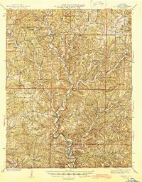
1945 Map of Thornfield
USGS Topo · Published 1945About this map
Little North Fork White River winds southward through this 1945 study of the Missouri Ozarks, serving as a primary corridor for small settlements like Theodosia and Isabella. The landscape is defined by its numerous rural schools and churches, including the uniquely named Barefoot Sch and Franklin Grove Ch, which suggest a era of tightly-knit upland communities before the massive landscape changes of later dam projects. In the north, Thornfield sits at a crossroads of the regional terrain, while the southern boundary tracks the state line between Missouri and Arkansas. The map provides significant genealogical value for those tracing family ties in Ozark Co, Missouri, and Marion Co, Arkansas, identifying specific sites such as Friend Cem and Hicks Cem and various named high points like Peacock Bald and McVey Bald.
Find a feature on this map
74 named features on this map. Tap any name to fly to it.
Don’t see what you’re looking for? This feature index may not catch every label — zoom into the map to look around manually.
Map Details
Editions of this 1945 Thornfield Map
2 editions found

Other maps of this area

1890 · Mountain Home
USGS Topo · 1:125,000

1891 · Mountain Home
USGS Topo · 1:125,000

1893 · Yellville
USGS Topo · 1:125,000

1894 · Mountain Home
USGS Topo · 1:125,000

1903 · Yellville
USGS Topo · 1:125,000

1905 · Yellville
USGS Topo · 1:125,000

1929 · Yellville
USGS Topo · 1:125,000

1934 · Gainesville
USGS Topo · 1:48,000

1936 · Thornfield
USGS Topo · 1:48,000

1936 · Ava
USGS Topo · 1:48,000