1970s Maps of Washington, Missouri
Explore 2 historic maps of Washington from the 1970s. These maps offer a rare glimpse into what life looked like during the 1970s — showing old roads, neighborhoods, homes, and landmarks that have changed or disappeared over time.
Whether you're researching your family's past, planning a metal detecting trip, or studying how Washington's landscape evolved across the 1970s, these high-resolution maps are a powerful tool for exploring the history of this region.
- Focus on a specific era: All maps on this page are from the 1970s, giving you a focused view of this time period.
- See what’s changed: Compare century-old streets, trails, and buildings to today's modern landscape using overlays and satellite layers.
- Research with precision: Use these maps for genealogy, historical research, land use analysis, or educational projects.
- View, download, or print: Maps are fully viewable online in high resolution, and can be downloaded or printed for your own records.
Start exploring Washington's history through authentic maps from the 1970s. This is your window into the past.
Washington, MO maps
(2)- 1972 Map of Washington East, 1973 Print
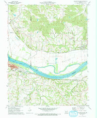 1972 Washington East1973 Print · USGSThe riverfront at Washington and the quiet hills of Augusta are captured here in the early 1970s. Researchers can trace the dual rail lines of the Missouri Pacific and Missouri Kansas Texas, alongside local landmarks like St Peters Cem and South Point Sch.
 - 1973 Map of Washington West, 1974 Print
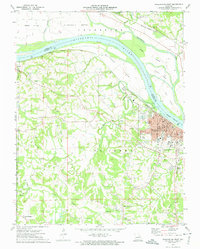 1973 Washington West1974 Print · USGSFranklin and Warren counties meet along the Missouri River in the 1970s as the town of Washington grows around its rail and river roots. Researchers can trace family history through sites like Newport Cem, the Daniel Boone Monument, and the rural crossroads at Clover Bottom.2 unique versions available
End of results
Showing maps 1-2 of 2
Top cities near Washington
- O'Fallon historical maps
- Wentzville historical maps
- Union historical maps
- Pacific historical maps
- Saint Clair historical maps
- Gray Summit historical maps
See more
Top neighborhoods of Washington
Frequently asked questions
- What are the different types of historical maps available for Washington?
- What is the oldest map of Washington?
- Where can I purchase historical maps of Washington for my home or office?
- Where can I download high-res historical maps of Washington?
- Are there historical topographic maps available for Washington?
- Is there historical aerial imagery available for Washington?
- Where are historical maps of Washington sourced from?