1980s Maps of Galt, Missouri
Explore 3 historic maps of Galt from the 1980s. These maps offer a rare glimpse into what life looked like during the 1980s — showing old roads, neighborhoods, homes, and landmarks that have changed or disappeared over time.
Whether you're researching your family's past, planning a metal detecting trip, or studying how Galt's landscape evolved across the 1980s, these high-resolution maps are a powerful tool for exploring the history of this region.
- Focus on a specific era: All maps on this page are from the 1980s, giving you a focused view of this time period.
- See what’s changed: Compare century-old streets, trails, and buildings to today's modern landscape using overlays and satellite layers.
- Research with precision: Use these maps for genealogy, historical research, land use analysis, or educational projects.
- View, download, or print: Maps are fully viewable online in high resolution, and can be downloaded or printed for your own records.
Start exploring Galt's history through authentic maps from the 1980s. This is your window into the past.
Galt, MO maps
(3)- 1981 Map of Trenton
 1981 Trenton1981 Print · USGSNorthern Missouri in the early eighties remains a landscape defined by its river valleys and intersecting rail lines. Genealogists and local historians can trace the development of riverside towns like Trenton and Princeton or locate smaller rural junctions such as Humphreys and Brimson.
 - 1984 Map of Laredo
 1984 Laredo1984 Print · USGSGrundy County's rural townships are shown here in the mid-1980s, revealing the agricultural landscape and small-town footprints of the era. Researchers can trace the street grids of Laredo and Galt or locate homesteads near Medicine Creek and Dunlap.
 - 1984 Map of Galt, 1985 Print
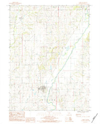
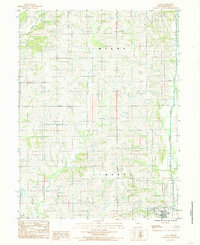 1984 Galt1985 Print · USGSNorthern Missouri farmland in the early eighties centers on the village of Galt and its surrounding townships. Researchers can trace rural cemeteries labeled Cem and the intricate drainage of Medicine Creek and East Honey Creek.
End of results
Showing maps 1-3 of 3
Top cities near Galt
- Trenton historical maps
- Spickard historical maps
- Browning historical maps
- Laredo historical maps
- Purdin historical maps
- Chula historical maps
See more
Frequently asked questions
- What are the different types of historical maps available for Galt?
- What is the oldest map of Galt?
- Where can I purchase historical maps of Galt for my home or office?
- Where can I download high-res historical maps of Galt?
- Are there historical topographic maps available for Galt?
- Is there historical aerial imagery available for Galt?
- Where are historical maps of Galt sourced from?