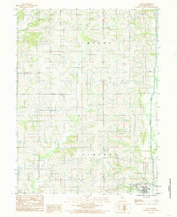
1984 Map of Galt
USGS Topo · Published 1985About this map
Galt serves as the primary hub of activity in this 1980s landscape, situated in the southeastern corner where the regional terrain begins to flatten toward the waterways. The area is defined by a dense network of drainage systems, including Medicine Creek and its various tributaries like Little Birch Branch and Little No Creek. These waterways dictate the boundaries and rural layout of townships such as Liberty, Myers, Lincoln, and Franklin.
Find a feature on this map
11 named features on this map. Tap any name to fly to it.
Don’t see what you’re looking for? This feature index may not catch every label — zoom into the map to look around manually.
Map Details
Editions of this 1984 Galt Map
This is the sole edition of this map. No revisions or reprints were ever made.
Other maps of this area

1946 · Princeton
USGS Topo · 1:62,500

1946 · Galt
USGS Topo · 1:62,500

1948 · Princeton
USGS Topo · 1:62,500

1948 · Trenton
USGS Topo · 1:62,500

1949 · Galt
USGS Topo · 1:62,500

1954 · Centerville
USGS Topo · 1:250,000

1957 · Centerville
USGS Topo · 1:250,000

1958 · Centerville
USGS Topo · 1:250,000

1964 · Harris
USGS Topo · 1:24,000

1964 · Half Rock
USGS Topo · 1:24,000