
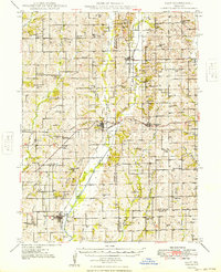
1949 Map of Galt
USGS Topo · Published 1949About this map
The agrarian landscape of northern Missouri is centered here on Galt, a community established at the convergence of two forks of Medicine Creek. In this mid-century period, the regional economy relies heavily on the Chicago Milwaukee St Paul and Pacific Railroad, which connects Laredo and Humphreys across a terrain marked by an extensive network of country schools. These educational hubs, such as Mud College Sch and Prairie Dale Sch, reflect a time of dense rural settlement before the consolidation of school districts. To the west, the village of Dunlap is linked by an Abandoned Railroad, signaling shifts in the local transportation network. Notable landmarks like the Landing Field near Galt and small family burial grounds including Maxey Cem provide specific points of interest for genealogists tracing local residents across Grundy and Sullivan counties.
Find a feature on this map
95 named features on this map. Tap any name to fly to it.
Don’t see what you’re looking for? This feature index may not catch every label — zoom into the map to look around manually.
Map Details
Editions of this 1949 Galt Map
2 editions found
Other maps of this area

1921 · Chillicothe
USGS Topo · 1:62,500

1923 · Chillicothe
USGS Topo · 1:62,500

1924 · Chula
USGS Topo · 1:62,500

1946 · Princeton
USGS Topo · 1:62,500

1946 · Brookfield
USGS Topo · 1:62,500

1946 · Galt
USGS Topo · 1:62,500

1947 · Chula
USGS Topo · 1:62,500

1948 · Princeton
USGS Topo · 1:62,500

1948 · Brookfield
USGS Topo · 1:62,500

1948 · Trenton
USGS Topo · 1:62,500