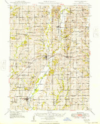
1949 Map of Galt
USGS Topo · Published 1949About this map
Medicine Creek and its many branches, including the West Fork and East Fork, dominate this north-central Missouri landscape at the end of the 1940s. The region is defined by a dense network of rural infrastructure, with small towns like Galt and Humphreys serving as local hubs. Transportation is anchored by two major rail lines: the Chicago Milwaukee St Paul and Pacific Railroad and the Chicago Rock Island and Pacific Railroad. The map reveals a high concentration of one-room schoolhouses and country churches that were the heart of these farming communities, such as Mud College School and Starlight Church. A notable Landing Field is situated near Dunlap, while the convergence of three counties—Grundy, Sullivan, and Linn—highlights the jurisdictional boundaries that shaped local administration and property records.
Find a feature on this map
76 named features on this map. Tap any name to fly to it.
Don’t see what you’re looking for? This feature index may not catch every label — zoom into the map to look around manually.
Map Details
Editions of this 1949 Galt Map
2 editions found

Other maps of this area

1921 · Chillicothe
USGS Topo · 1:62,500

1923 · Chillicothe
USGS Topo · 1:62,500

1924 · Chula
USGS Topo · 1:62,500

1946 · Princeton
USGS Topo · 1:62,500

1946 · Brookfield
USGS Topo · 1:62,500

1946 · Galt
USGS Topo · 1:62,500

1947 · Chula
USGS Topo · 1:62,500

1948 · Princeton
USGS Topo · 1:62,500

1948 · Brookfield
USGS Topo · 1:62,500

1948 · Trenton
USGS Topo · 1:62,500