1990s Maps of Hickory County, Missouri
Explore 5 historic maps of Hickory County from the 1990s. These maps offer a rare glimpse into what life looked like during the 1990s — showing old roads, neighborhoods, homes, and landmarks that have changed or disappeared over time.
Whether you're researching your family's past, planning a metal detecting trip, or studying how Hickory County's landscape evolved across the 1990s, these high-resolution maps are a powerful tool for exploring the history of this region.
- Focus on a specific era: All maps on this page are from the 1990s, giving you a focused view of this time period.
- See what’s changed: Compare century-old streets, trails, and buildings to today's modern landscape using overlays and satellite layers.
- Research with precision: Use these maps for genealogy, historical research, land use analysis, or educational projects.
- View, download, or print: Maps are fully viewable online in high resolution, and can be downloaded or printed for your own records.
Start exploring Hickory County's history through authentic maps from the 1990s. This is your window into the past.
Hickory County, MO maps
(5)- 1991 Map of Sentinel
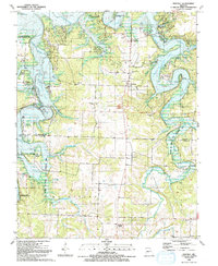 1991 Sentinel1991 Print · USGSHickory and Polk counties are shown at a time when the Ozark landscape was fully integrated with the waters of Pomme De Terre Lake. Researchers can locate legacy family sites like Stewart Cem or rural centers like Pittsburg and Sentinel.
 - 1991 Map of Weaubleau
 1991 Weaubleau1991 Print · USGSLife along the Hickory and St. Clair county line in the early nineties centered on small agricultural hubs and creek valleys. Genealogists and historians can trace the Old Railroad Grade past Gerster or locate the Robinson Cem and Kings Prairie Ch.
 - 1991 Map of Iconium
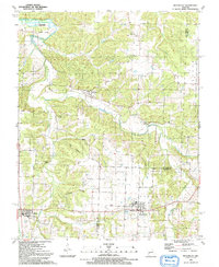
 1991 Iconium1991 Print · USGSSt. Clair County's rugged borderlands met the rising waters of the reservoir during the early nineties. Researchers can trace rural life at Iconium or find old community centers like Bear Creek Ch and the H Roe Bartle Scout Reservation.
 - 1991 Map of Elkton
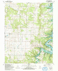 1991 Elkton1991 Print · USGSHickory and Polk Counties are captured here in the early nineties, documenting a landscape where rural settlements meet the waters of Pomme De Terre Lake. Genealogists can trace family footprints across Cook Cem, McCracken Cem, and the Old Railroad Grade.
 - 1991 Map of Humansville
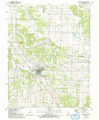 1991 Humansville1991 Print · USGSThe Polk County countryside near Humansville is shown here in the early nineties, centered on a landscape of prairie and creek valleys. Researchers can trace family history through numerous local sites like Flemington Cem, Rondo, and the Old Railroad Grade.
End of results
Showing maps 1-5 of 5
Top cities of Hickory County
- Weaubleau historical maps
- Hermitage historical maps
- Wheatland historical maps
- Cross Timbers historical maps
- Preston historical maps
Frequently asked questions
- What are the different types of historical maps available for Hickory County?
- What is the oldest map of Hickory County?
- Where can I purchase historical maps of Hickory County for my home or office?
- Where can I download high-res historical maps of Hickory County?
- Are there historical topographic maps available for Hickory County?
- Is there historical aerial imagery available for Hickory County?
- Where are historical maps of Hickory County sourced from?