1940s Maps of Hickory County, Missouri
Explore 10 historic maps of Hickory County from the 1940s. These maps offer a rare glimpse into what life looked like during the 1940s — showing old roads, neighborhoods, homes, and landmarks that have changed or disappeared over time.
Whether you're researching your family's past, planning a metal detecting trip, or studying how Hickory County's landscape evolved across the 1940s, these high-resolution maps are a powerful tool for exploring the history of this region.
- Focus on a specific era: All maps on this page are from the 1940s, giving you a focused view of this time period.
- See what’s changed: Compare century-old streets, trails, and buildings to today's modern landscape using overlays and satellite layers.
- Research with precision: Use these maps for genealogy, historical research, land use analysis, or educational projects.
- View, download, or print: Maps are fully viewable online in high resolution, and can be downloaded or printed for your own records.
Start exploring Hickory County's history through authentic maps from the 1940s. This is your window into the past.
Hickory County, MO maps
(10)- 1940 Map of Weaubleau, 1954 Print
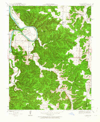
 1940 Weaubleau1954 Print · USGSThe St. Clair and Hickory county line area comes into focus in the 1940s, showing a landscape of rail-linked towns and local school districts. Trace family roots at Robinson Cem or explore the old routes through Gerster, Collins, and Weaubleau.2 unique versions available
 - 1940 Map of Iconium, 1963 Print
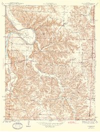
 1940 Iconium1963 Print · USGSNear the bend of the Osage River just before the war, this rural landscape reveals a network of Missouri hollows and prairie lands. Genealogists can trace early homesteads and community hubs like Iconium, Liberty Sch, and the Boy Scout Camp.2 unique versions available
 - 1942 Map of Elkton, 1982 Print
 1942 Elkton1982 Print · USGSHickory and Polk Counties are captured here during a period of transition as the river valley was reshaped by new infrastructure. Genealogists can trace family roots through the Round Tree Cem, Mission Chapel, and many rural schoolhouses like Elkton Sch.
 - 1944 Map of Humansville
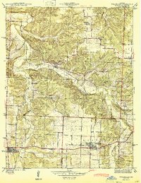
 1944 Humansville1944 Print · USGSNear the intersection of three counties in the mid-1940s, this area centered on a thriving rail and agricultural landscape. Local historians can trace family roots through numerous country schoolhouses like Elm Grove Sch and cemeteries such as Richardson Cem.3 unique versions available
 - 1944 Map of Weaubleau
 1944 Weaubleau1944 Print · USGSHickory and St. Clair Counties come into focus during the early 1940s as the railroad and rural school districts defined local life. Researchers can trace family-named landmarks and early homesteads near Weaubleau, Gerster, and Robinson Cem.2 unique versions available
 - 1944 Map of Iconium
 1944 Iconium1944 Print · USGSThe Osage River bends through the St. Clair County hills in the early 1940s, revealing a landscape of steep hollows and upland farms. Trace local family roots at Iconium, Corbin Ch, and several rural schoolhouses like Square Prairie Sch.2 unique versions available
 - 1945 Map of Fristoe
 1945 Fristoe1945 Print · USGSBenton and Hickory Counties appear here in the mid-1940s, showing a landscape of Ozark ridges and river bottomlands before major mid-century changes. Researchers can trace ancestral locations through numerous rural schools and river crossings like Evening Shade Sch and Little Mill Creek Ford.3 unique versions available
 - 1947 Map of Jefferson City, 1949 Print
 1947 Jefferson City1949 Print · USGSCentral Missouri and the northern Ozarks come into focus in this late 1940s survey of the river-and-rail landscape. Genealogists and historians can trace the growth of Jefferson City and Sedalia or locate family roots near Bagnell Dam and the Lake of the Ozarks.
 - 1949 Map of Elkton, 1969 Print
 1949 Elkton1969 Print · USGSMid-century Hickory and Polk counties are defined by the winding Pomme De Terre River and a quiet network of rural settlements. Genealogists can trace family footprints through a remarkable density of local schools like Royal Sch and churches including Durnell Chapel.2 unique versions available
 - 1949 Map of Sentinel, 1973 Print
 1949 Sentinel1973 Print · USGSThe Pomme de Terre River valley in Hickory and Polk Counties is shown here just after the war, before modern development altered the rural landscape. Researchers can locate numerous vanished landmarks and family sites like Pittsburg Ch, Stewart Cem, and the Rose Hill Sch.2 unique versions available
End of results
Showing maps 1-10 of 10
Top cities of Hickory County
- Weaubleau historical maps
- Hermitage historical maps
- Wheatland historical maps
- Cross Timbers historical maps
- Preston historical maps
Frequently asked questions
- What are the different types of historical maps available for Hickory County?
- What is the oldest map of Hickory County?
- Where can I purchase historical maps of Hickory County for my home or office?
- Where can I download high-res historical maps of Hickory County?
- Are there historical topographic maps available for Hickory County?
- Is there historical aerial imagery available for Hickory County?
- Where are historical maps of Hickory County sourced from?