1960s Maps of Hickory County, Missouri
Explore 4 historic maps of Hickory County from the 1960s. These maps offer a rare glimpse into what life looked like during the 1960s — showing old roads, neighborhoods, homes, and landmarks that have changed or disappeared over time.
Whether you're researching your family's past, planning a metal detecting trip, or studying how Hickory County's landscape evolved across the 1960s, these high-resolution maps are a powerful tool for exploring the history of this region.
- Focus on a specific era: All maps on this page are from the 1960s, giving you a focused view of this time period.
- See what’s changed: Compare century-old streets, trails, and buildings to today's modern landscape using overlays and satellite layers.
- Research with precision: Use these maps for genealogy, historical research, land use analysis, or educational projects.
- View, download, or print: Maps are fully viewable online in high resolution, and can be downloaded or printed for your own records.
Start exploring Hickory County's history through authentic maps from the 1960s. This is your window into the past.
Hickory County, MO maps
(4)- 1960 Map of Cross Timbers, 1961 Print
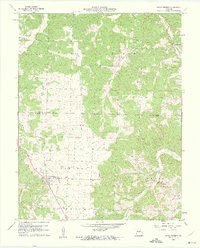 1960 Cross Timbers1961 Print · USGSThe community of Cross Timbers and the surrounding Hickory County landscape are captured here in the early sixties. Genealogists and local historians can trace family locations near Davis Cem, Bethel Ch, and the waters of Turkey Creek.2 unique versions available
 - 1960 Map of Climax Springs, 1961 Print
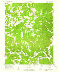 1960 Climax Springs1961 Print · USGSClimax Springs and the Little Niangua River country are captured here at the start of the 1960s, showing a landscape of deep hollows and high ridges. Researchers can trace rural community roots through local landmarks like Wiseman Ch, Green Ridge Cem, and the Climax Springs Lookout Tower.3 unique versions available
 - 1960 Map of Branch, 1961 Print
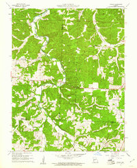 1960 Branch1961 Print · USGSCamden County was a land of quiet creek valleys and scattered hilltop churches at the dawn of the 1960s. Family historians can trace ancestral sites along the Little Niangua River, from the Stanton Cem to the Branch Lookout Tower.2 unique versions available
 - 1960 Map of Preston, 1961 Print
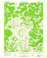 1960 Preston1961 Print · USGSPreston and the Missouri Ozark borderlands are documented here at the start of the 1960s, showing a landscape of small family farms and timber. Genealogists can trace rural roots through the locations of Fisher Cem, Olive Point Ch, and the Morgan Sch.2 unique versions available
End of results
Showing maps 1-4 of 4
Top cities of Hickory County
- Weaubleau historical maps
- Hermitage historical maps
- Wheatland historical maps
- Cross Timbers historical maps
- Preston historical maps
Frequently asked questions
- What are the different types of historical maps available for Hickory County?
- What is the oldest map of Hickory County?
- Where can I purchase historical maps of Hickory County for my home or office?
- Where can I download high-res historical maps of Hickory County?
- Are there historical topographic maps available for Hickory County?
- Is there historical aerial imagery available for Hickory County?
- Where are historical maps of Hickory County sourced from?