1980s Maps of Hickory County, Missouri
Explore 12 historic maps of Hickory County from the 1980s. These maps offer a rare glimpse into what life looked like during the 1980s — showing old roads, neighborhoods, homes, and landmarks that have changed or disappeared over time.
Whether you're researching your family's past, planning a metal detecting trip, or studying how Hickory County's landscape evolved across the 1980s, these high-resolution maps are a powerful tool for exploring the history of this region.
- Focus on a specific era: All maps on this page are from the 1980s, giving you a focused view of this time period.
- See what’s changed: Compare century-old streets, trails, and buildings to today's modern landscape using overlays and satellite layers.
- Research with precision: Use these maps for genealogy, historical research, land use analysis, or educational projects.
- View, download, or print: Maps are fully viewable online in high resolution, and can be downloaded or printed for your own records.
Start exploring Hickory County's history through authentic maps from the 1980s. This is your window into the past.
Hickory County, MO maps
(12)- 1980 Map of Elkton, 1982 Print
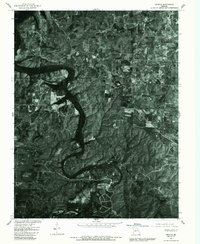
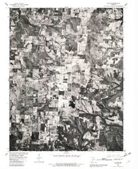 1980 Elkton1982 Print · USGSHickory County's rural landscape is captured here in the early 1980s as the regional topography transitions from river valley to reservoir. Genealogists and land researchers can trace the small settlements of Elkton and Rondo alongside the banks of Weaubleau Creek.
 - 1980 Map of Hermitage, 1982 Print
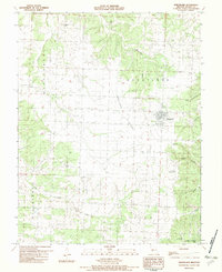
 1980 Hermitage1982 Print · USGSHickory County, Missouri, is captured in the early eighties as the landscape adapted to the presence of a major reservoir. Researchers can trace the original path of the Pomme De Terre River and locate small communities like Hermitage, Galmey, and Nemo.
 - 1980 Map of Wheatland, 1982 Print
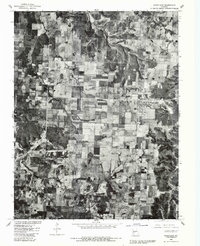 1980 Wheatland1982 Print · USGSHickory County farmland and small crossroads settlements are seen in sharp aerial detail in the early eighties. Local researchers can trace property lines and field patterns near Wheatland and the community of Butcher.
 - 1980 Map of Sentinel, 1982 Print
 1980 Sentinel1982 Print · USGSHickory County's winding lakefront and rural crossroads are captured in high detail in the early eighties. Trace the fingers of Pomme De Terre Lake near settlements like Pittsburg and Adonis or the remote junction at Mohawk Corner.
 - 1980 Map of Quincy, 1982 Print
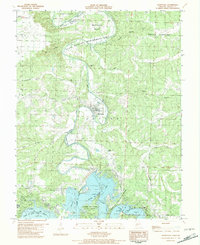
 1980 Quincy1982 Print · USGSHickory County farmsteads and wooded bottomlands are shown in clear aerial detail during the early eighties. Researchers can trace land-use patterns around Bentonville and see the early footprint of the Harry S Truman Reservoir.
 - 1980 Map of Fristoe, 1986 Print
 1980 Fristoe1986 Print · USGSHickory County comes into focus in the early eighties through this detailed orthophotoquad. Genealogists and local researchers can trace old road alignments and the precise boundaries of rural settlements like Fristoe, Avery, and White Cloud.
 - 1982 Map of Hermitage
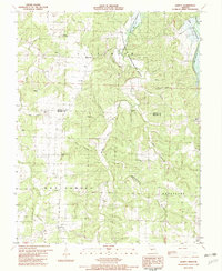
 1982 Hermitage1982 Print · USGSHickory County's river-driven landscape is captured here in the early eighties, centered on the county seat and the rising reservoir waters. Genealogists and local historians can locate Dorman Cem, the community of Galmey, and the grounds of Pomme De Terre State Park.
 - 1982 Map of Quincy
 1982 Quincy1982 Print · USGSHickory and Benton counties are documented here in the early eighties as the landscape adapted to the new Harry S Truman Reservoir. Researchers can trace old family lines through landmarks like Mt Zion Cem, Bentonville, and Pleasant Grove Ch.
 - 1982 Map of Fristoe
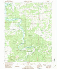 1982 Fristoe1982 Print · USGSThe Pomme de Terre River valley in the early eighties shows a landscape adapting to the new shoreline of the Harry S Truman Reservoir. Local historians can trace family locations at Fristoe and Avery, or find rural landmarks like Spring Branch Ch and South New Home Cem.
 - 1982 Map of Wheatland
 1982 Wheatland1982 Print · USGSHickory County's rural landscape is captured here in the early eighties, centered on the settlement of Wheatland and the Wheatland Prairie. Genealogists and local historians can trace family-named sites such as Sumner Cem and Pope Cem or explore the karst features of Vanderman Cave.
 - 1983 Map of Harry S Truman Reservoir, 1984 Print
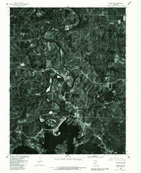
 1983 Harry S Truman Reservoir1984 Print · USGSBenton and Henry counties center on the vast Harry S Truman Reservoir in the early 1980s as the landscape adapted to its new shoreline. Genealogists and historians can trace old river crossings like Bledsoe Ferry, local landmarks like Mt Zion Ch, and unique settlements such as Tightwad.
 - 1984 Map of Bolivar
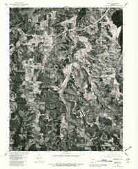
 1984 Bolivar1984 Print · USGSWestern Missouri in the mid-eighties shows a landscape shaped by large-scale water management and rail commerce. Genealogists and historians can trace the development of towns like Bolivar and El Dorado Springs alongside the massive Stockton Lake.
End of results
Showing maps 1-12 of 12
Top cities of Hickory County
- Weaubleau historical maps
- Hermitage historical maps
- Wheatland historical maps
- Cross Timbers historical maps
- Preston historical maps
Frequently asked questions
- What are the different types of historical maps available for Hickory County?
- What is the oldest map of Hickory County?
- Where can I purchase historical maps of Hickory County for my home or office?
- Where can I download high-res historical maps of Hickory County?
- Are there historical topographic maps available for Hickory County?
- Is there historical aerial imagery available for Hickory County?
- Where are historical maps of Hickory County sourced from?