1960s Maps of Holt County, Missouri
Explore 8 historic maps of Holt County from the 1960s. These maps offer a rare glimpse into what life looked like during the 1960s — showing old roads, neighborhoods, homes, and landmarks that have changed or disappeared over time.
Whether you're researching your family's past, planning a metal detecting trip, or studying how Holt County's landscape evolved across the 1960s, these high-resolution maps are a powerful tool for exploring the history of this region.
- Focus on a specific era: All maps on this page are from the 1960s, giving you a focused view of this time period.
- See what’s changed: Compare century-old streets, trails, and buildings to today's modern landscape using overlays and satellite layers.
- Research with precision: Use these maps for genealogy, historical research, land use analysis, or educational projects.
- View, download, or print: Maps are fully viewable online in high resolution, and can be downloaded or printed for your own records.
Start exploring Holt County's history through authentic maps from the 1960s. This is your window into the past.
Holt County, MO maps
(8)- 1960 Map of Kansas City
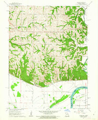
 1960 Kansas City1960 Print · USGSMid-century Kansas and Missouri meet at the river forks, showing a sprawling rail-and-river economy during the 1950s growth era. Genealogists and researchers can trace tribal lands like the Kickapoo Indian Reservation or follow the early interstate corridors through Saint Joseph and Independence.3 unique versions available
 - 1961 Map of Forbes, 1962 Print
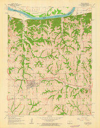
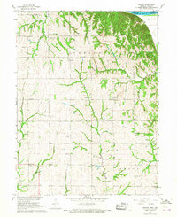
 1961 Forbes1962 Print · USGSThe confluence of the Nodaway River and Missouri River defines this Missouri-Kansas border landscape in the early sixties. Researchers can trace rural lineages through numerous country landmarks like Woodville Ch and the Brodbeck Cem.3 unique versions available
 - 1961 Map of Troy, 1962 Print
 1961 Troy1962 Print · USGSThe Missouri River bottomlands and the rail junction at Troy define the Doniphan County landscape in the early sixties. Genealogists can trace rural family roots through features like St Charles Cem, Old Sixty Sch, and the small settlement of Blair.2 unique versions available
 - 1961 Map of Amazonia, 1963 Print
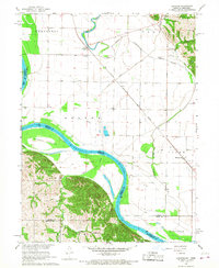
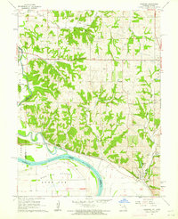 1961 Amazonia1963 Print · USGSThe Missouri and Nodaway rivers meet along this river-bottom landscape in the early sixties, where railroads follow the bluffs past small farming hubs. Genealogists can locate family names at Hackberry Cem and Old Union Cem or trace the old Brand Sch.2 unique versions available
 - 1965 Map of Rulo, 1966 Print
 1965 Rulo1966 Print · USGSThe river bluffs and bottomlands of Rulo come alive in the mid-1960s as the rail-and-river economy transitions into the modern era. Trace the path of the Chicago Burlington and Quincy railroad or locate local landmarks like Heater Cem and Brick Sch.
 - 1966 Map of Langdon, 1968 Print
 1966 Langdon1968 Print · USGSThe Missouri-Nebraska borderlands are captured here in the mid-sixties, where the Missouri River meets the Barada Hills. Genealogists and researchers can trace the rail lines of the Chicago Burlington and Quincy or locate rural sites like St Peters Ch and Hunter Cem.3 unique versions available
 - 1966 Map of Barada, 1968 Print
 1966 Barada1968 Print · USGSThe bluffs of eastern Richardson County overlook the Missouri River during the mid-sixties, revealing a landscape of established farmsteads and rural schools. Researchers can trace local genealogy through St Anns Cath Ch, Moorhead Cem, and the village of Barada.2 unique versions available
 - 1966 Map of Corning, 1968 Print
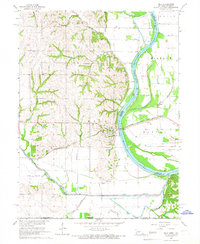
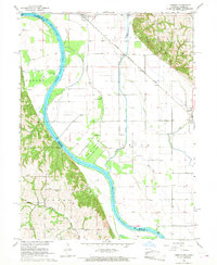 1966 Corning1968 Print · USGSCorning and Craig sit within the fertile Missouri River floodplain during the mid-1960s, a period of established rail transport and river management. Researchers can locate numerous family burial sites and rural institutions like Arago Cemetery, St Marys Church, and the Fargo School.2 unique versions available
End of results
Showing maps 1-8 of 8
Top cities of Holt County
- Mound City historical maps
- Oregon historical maps
- Forest City historical maps
- Maitland historical maps
- Craig historical maps
- Big Lake historical maps
See more
Frequently asked questions
- What are the different types of historical maps available for Holt County?
- What is the oldest map of Holt County?
- Where can I purchase historical maps of Holt County for my home or office?
- Where can I download high-res historical maps of Holt County?
- Are there historical topographic maps available for Holt County?
- Is there historical aerial imagery available for Holt County?
- Where are historical maps of Holt County sourced from?