1960s Maps of Warrensburg, Missouri
Explore 2 historic maps of Warrensburg from the 1960s. These maps offer a rare glimpse into what life looked like during the 1960s — showing old roads, neighborhoods, homes, and landmarks that have changed or disappeared over time.
Whether you're researching your family's past, planning a metal detecting trip, or studying how Warrensburg's landscape evolved across the 1960s, these high-resolution maps are a powerful tool for exploring the history of this region.
- Focus on a specific era: All maps on this page are from the 1960s, giving you a focused view of this time period.
- See what’s changed: Compare century-old streets, trails, and buildings to today's modern landscape using overlays and satellite layers.
- Research with precision: Use these maps for genealogy, historical research, land use analysis, or educational projects.
- View, download, or print: Maps are fully viewable online in high resolution, and can be downloaded or printed for your own records.
Start exploring Warrensburg's history through authentic maps from the 1960s. This is your window into the past.
Warrensburg, MO maps
(2)- 1962 Map of Warrensburg East, 1963 Print
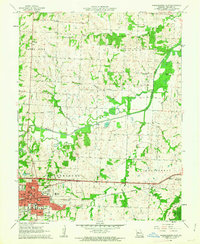 1962 Warrensburg East1963 Print · USGSWarrensburg and the Central Missouri State College campus are captured here in the early sixties as the city expanded east toward the Blackwater River. Researchers can locate family landmarks like Maxwell Cem or trace the rural landscape near Mt Zion Ch and Montserrat.2 unique versions available
 - 1962 Map of Warrensburg West, 1964 Print
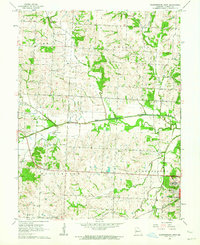 1962 Warrensburg West1964 Print · USGSMissouri's Johnson County rural townships come alive in the early sixties, showing the agricultural landscape between Centerview and Warrensburg. Genealogists can locate several local burial sites like Mount Maria Cem and landmarks like Jacoby Chapel near the Blackwater River.2 unique versions available
End of results
Showing maps 1-2 of 2
Top cities near Warrensburg
- Odessa historical maps
- Windsor historical maps
- Knob Noster historical maps
- Concordia historical maps
- Leeton historical maps
- Chilhowee historical maps
See more
Top neighborhoods of Warrensburg
Frequently asked questions
- What are the different types of historical maps available for Warrensburg?
- What is the oldest map of Warrensburg?
- Where can I purchase historical maps of Warrensburg for my home or office?
- Where can I download high-res historical maps of Warrensburg?
- Are there historical topographic maps available for Warrensburg?
- Is there historical aerial imagery available for Warrensburg?
- Where are historical maps of Warrensburg sourced from?