1970s Maps of Old Monroe, Missouri
Explore 2 historic maps of Old Monroe from the 1970s. These maps offer a rare glimpse into what life looked like during the 1970s — showing old roads, neighborhoods, homes, and landmarks that have changed or disappeared over time.
Whether you're researching your family's past, planning a metal detecting trip, or studying how Old Monroe's landscape evolved across the 1970s, these high-resolution maps are a powerful tool for exploring the history of this region.
- Focus on a specific era: All maps on this page are from the 1970s, giving you a focused view of this time period.
- See what’s changed: Compare century-old streets, trails, and buildings to today's modern landscape using overlays and satellite layers.
- Research with precision: Use these maps for genealogy, historical research, land use analysis, or educational projects.
- View, download, or print: Maps are fully viewable online in high resolution, and can be downloaded or printed for your own records.
Start exploring Old Monroe's history through authentic maps from the 1970s. This is your window into the past.
Old Monroe, MO maps
(2)- 1972 Map of Maryknoll, 1973 Print
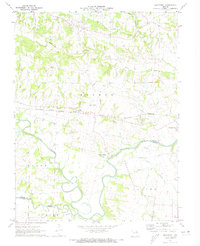 1972 Maryknoll1973 Print · USGSLincoln and St. Charles counties meet along the winding river valley in the early seventies, a landscape shaped by rail and water. Genealogists can locate family landmarks such as Highland Prairie Ch and St Pauls Ch or trace the early paths of Ethlyn and Old Monroe.
 - 1979 Map of Maryknoll, 1980 Print
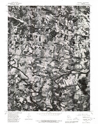 1979 Maryknoll1980 Print · USGSLincoln County farmland and river bends appear in sharp detail just before the 1980s. Genealogists and historians can trace the rural layouts of Old Monroe and Chain of Rocks along the banks of the Cuivre River.
End of results
Showing maps 1-2 of 2
Top cities near Old Monroe
- O'Fallon historical maps
- Saint Charles historical maps
- Saint Peters historical maps
- Wentzville historical maps
- Maryland Heights historical maps
- Harvester historical maps
See more
Top neighborhoods of Old Monroe
Frequently asked questions
- What are the different types of historical maps available for Old Monroe?
- What is the oldest map of Old Monroe?
- Where can I purchase historical maps of Old Monroe for my home or office?
- Where can I download high-res historical maps of Old Monroe?
- Are there historical topographic maps available for Old Monroe?
- Is there historical aerial imagery available for Old Monroe?
- Where are historical maps of Old Monroe sourced from?