1980s Maps of Utica, Missouri
Explore 5 historic maps of Utica from the 1980s. These maps offer a rare glimpse into what life looked like during the 1980s — showing old roads, neighborhoods, homes, and landmarks that have changed or disappeared over time.
Whether you're researching your family's past, planning a metal detecting trip, or studying how Utica's landscape evolved across the 1980s, these high-resolution maps are a powerful tool for exploring the history of this region.
- Focus on a specific era: All maps on this page are from the 1980s, giving you a focused view of this time period.
- See what’s changed: Compare century-old streets, trails, and buildings to today's modern landscape using overlays and satellite layers.
- Research with precision: Use these maps for genealogy, historical research, land use analysis, or educational projects.
- View, download, or print: Maps are fully viewable online in high resolution, and can be downloaded or printed for your own records.
Start exploring Utica's history through authentic maps from the 1980s. This is your window into the past.
Utica, MO maps
(5)- 1981 Map of Chillicothe
 1981 Chillicothe1981 Print · USGSNorth Missouri's Grand River basin comes into focus during the early 1980s, showcasing a network of vital rail lines and river settlements. Genealogists and historians can trace rail-town development from Gallatin to Brookfield and explore extensive conservation lands like Swan Lake National Wildlife Refuge.
 - 1984 Map of Utica East
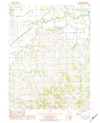 1984 Utica East1984 Print · USGSLivingston County in the early 1980s was defined by its relationship with the Grand River and the rural townships of Green and Blue Mound. Genealogists and local historians can trace family locations near Utica, old country cemeteries, and waterways like Shoal Creek.
 - 1984 Map of Utica West, 1985 Print
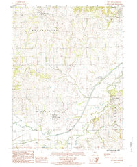 1984 Utica West1985 Print · USGSLivingston County in the early 1980s reveals a network of rural townships and winding creek bottoms before modern agricultural shifts. Genealogists and local historians can trace the foundations of Mooresville, Ludlow, and the high ground of Blue Mound.
 - 1984 Map of Chillicothe, 1985 Print
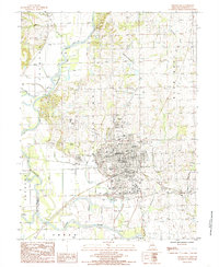 1984 Chillicothe1985 Print · USGSChillicothe and its surrounding townships are captured in the early eighties as the town expanded near the Thompson River and Grand River junction. Local historians can trace family roots through numerous Cem sites and landmarks like the Drive-In Theater and Radio Tower (KCHI).
 - 1984 Map of Sampsel, 1985 Print
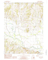 1984 Sampsel1985 Print · USGSLivingston County in the early 1980s reveals a landscape defined by the winding Grand River and its protective levee system. Genealogists and local historians can trace the rural crossroads of Sampsel, locate numerous rural cemeteries, and explore the drainage of Polecat Creek.
End of results
Showing maps 1-5 of 5
Top cities near Utica
- Chillicothe historical maps
- Braymer historical maps
- Jamesport historical maps
- Breckenridge historical maps
- Blue Mound historical maps
- Sampsel historical maps
See more
Frequently asked questions
- What are the different types of historical maps available for Utica?
- What is the oldest map of Utica?
- Where can I purchase historical maps of Utica for my home or office?
- Where can I download high-res historical maps of Utica?
- Are there historical topographic maps available for Utica?
- Is there historical aerial imagery available for Utica?
- Where are historical maps of Utica sourced from?