1930s Maps of Madison County, Missouri
Explore 5 historic maps of Madison County from the 1930s. These maps offer a rare glimpse into what life looked like during the 1930s — showing old roads, neighborhoods, homes, and landmarks that have changed or disappeared over time.
Whether you're researching your family's past, planning a metal detecting trip, or studying how Madison County's landscape evolved across the 1930s, these high-resolution maps are a powerful tool for exploring the history of this region.
- Focus on a specific era: All maps on this page are from the 1930s, giving you a focused view of this time period.
- See what’s changed: Compare century-old streets, trails, and buildings to today's modern landscape using overlays and satellite layers.
- Research with precision: Use these maps for genealogy, historical research, land use analysis, or educational projects.
- View, download, or print: Maps are fully viewable online in high resolution, and can be downloaded or printed for your own records.
Start exploring Madison County's history through authentic maps from the 1930s. This is your window into the past.
Madison County, MO maps
(5)- 1930 Map of Coldwater
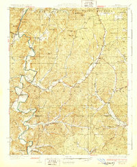 1930 Coldwater1930 Print · USGSMadison County's rugged river valleys and early Ozark settlements are documented here between the world wars. Genealogists can trace family roots at Revelle Cem, early river crossings like Wade Ford, and local centers like Coldwater or French Mills.4 unique versions available
 - 1933 Map of Marquand, 1966 Print
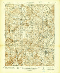
 1933 Marquand1966 Print · USGSMadison and Bollinger counties are shown in the early 1930s, documenting a landscape defined by the Missouri Pacific rail corridor and the Castor River. Genealogists can trace family landmarks like Younts Store, the Starkey Mine, and numerous remote burial grounds including the Whitener Cem.2 unique versions available
 - 1937 Map of Ironton
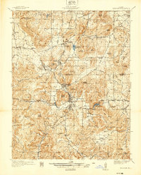 1937 Ironton1937 Print · USGSThe Arcadia Valley in the late 1930s is documented here during a period of established mining and rail activity. Researchers can trace family roots at Rebel Cem and Algire Cem, or locate rural landmarks like King Sch and the Devils Toll Gate.
 - 1938 Map of Marquand
 1938 Marquand1938 Print · USGSThe Missouri Ozarks borderlands appear here in the late 1930s, showing a landscape of river-valley towns and hilltop mines. Researchers can trace ancestral locations through dozens of rural sites, including Rhodes Chapel, Starke Mine, and the Marquand rail depot.2 unique versions available
 - 1939 Map of Fredericktown
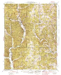
 1939 Fredericktown1939 Print · USGSMadison County's mineral heart comes alive in this late 1930s survey of the Missouri Ozarks. Genealogists and historians can trace old homesteads and mining districts like Mine La Motte, the Catherine Mines, and the rural community of Slabtown.
End of results
Showing maps 1-5 of 5
Top cities of Madison County
Frequently asked questions
- What are the different types of historical maps available for Madison County?
- What is the oldest map of Madison County?
- Where can I purchase historical maps of Madison County for my home or office?
- Where can I download high-res historical maps of Madison County?
- Are there historical topographic maps available for Madison County?
- Is there historical aerial imagery available for Madison County?
- Where are historical maps of Madison County sourced from?