1960s Maps of Madison County, Missouri
Explore 6 historic maps of Madison County from the 1960s. These maps offer a rare glimpse into what life looked like during the 1960s — showing old roads, neighborhoods, homes, and landmarks that have changed or disappeared over time.
Whether you're researching your family's past, planning a metal detecting trip, or studying how Madison County's landscape evolved across the 1960s, these high-resolution maps are a powerful tool for exploring the history of this region.
- Focus on a specific era: All maps on this page are from the 1960s, giving you a focused view of this time period.
- See what’s changed: Compare century-old streets, trails, and buildings to today's modern landscape using overlays and satellite layers.
- Research with precision: Use these maps for genealogy, historical research, land use analysis, or educational projects.
- View, download, or print: Maps are fully viewable online in high resolution, and can be downloaded or printed for your own records.
Start exploring Madison County's history through authentic maps from the 1960s. This is your window into the past.
Madison County, MO maps
(6)- 1960 Map of Rolla
 1960 Rolla1960 Print · USGSThe Ozark Highlands in the mid-twentieth century reveal a landscape of deep timber and heavy industry. Researchers can trace the rail-and-mine economy through the St Louis-San Francisco RR and the Iron Mountain Mine, alongside the growth of Fort Leonard Wood.
 - 1966 Map of Rolla
 1966 Rolla1966 Print · USGSThe Missouri Ozarks are revealed here in the mid-1960s, showing the intersection of heavy industry and sprawling national forests. Trace the development of the Lead Belt near Flat River or locate family roots in vanished hamlets like Enough and Howes Mill.
 - 1968 Map of Brunot, 1969 Print
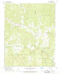 1968 Brunot1969 Print · USGSThe rural hills of Iron and Wayne counties are captured here in the late sixties as the local landscape remained deeply tied to its branching creek valleys. Genealogists and researchers can locate several remote burial sites such as Brewington Cem and Hunter Cem or trace the boundaries of Sam A Baker State Park.3 unique versions available
 - 1968 Map of Des Arc NE, 1969 Print
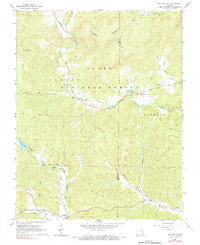 1968 Des Arc NE1969 Print · USGSIron and Madison County hills come into focus in the late 1960s, showing a backcountry landscape crisscrossed by jeep trails and water gaps. Genealogists can trace family connections through numerous sites like Shoemaker Cem and the settlement of Minimum.2 unique versions available
 - 1968 Map of Lake Killarney, 1970 Print
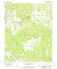 1968 Lake Killarney1970 Print · USGSThe adjoining communities of Ironton and Arcadia are captured here in the late sixties as they developed alongside the Clark National Forest. Researchers can locate numerous family burial sites like Sutton Cem and Allgier Cem or trace the early lakeside developments at Lake Killarney.2 unique versions available
 - 1968 Map of Iron Mountain Lake, 1970 Print
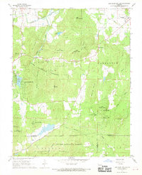 1968 Iron Mountain Lake1970 Print · USGSIn the Missouri Ozarks during the late 1960s, the terrain south of the St Francis River was a mix of national forest and active mining communities. Local historians can trace old property lines and cemetery locations like German Cem, or explore the rail network through Iron Mountain Lake and Doe Run.2 unique versions available
End of results
Showing maps 1-6 of 6
Top cities of Madison County
Frequently asked questions
- What are the different types of historical maps available for Madison County?
- What is the oldest map of Madison County?
- Where can I purchase historical maps of Madison County for my home or office?
- Where can I download high-res historical maps of Madison County?
- Are there historical topographic maps available for Madison County?
- Is there historical aerial imagery available for Madison County?
- Where are historical maps of Madison County sourced from?