1980s Maps of Madison County, Missouri
Explore 14 historic maps of Madison County from the 1980s. These maps offer a rare glimpse into what life looked like during the 1980s — showing old roads, neighborhoods, homes, and landmarks that have changed or disappeared over time.
Whether you're researching your family's past, planning a metal detecting trip, or studying how Madison County's landscape evolved across the 1980s, these high-resolution maps are a powerful tool for exploring the history of this region.
- Focus on a specific era: All maps on this page are from the 1980s, giving you a focused view of this time period.
- See what’s changed: Compare century-old streets, trails, and buildings to today's modern landscape using overlays and satellite layers.
- Research with precision: Use these maps for genealogy, historical research, land use analysis, or educational projects.
- View, download, or print: Maps are fully viewable online in high resolution, and can be downloaded or printed for your own records.
Start exploring Madison County's history through authentic maps from the 1980s. This is your window into the past.
Madison County, MO maps
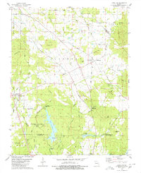
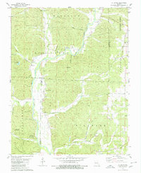
(14)- 1980 Map of Cherokee Pass
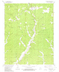 1980 Cherokee Pass1980 Print · USGSMadison County's forested uplands and remote hollows are documented here during the late 1970s. Researchers can trace family history through several rural burial sites and landmarks like Revelle Cem, Twelvemile Ch, and the high peak of Matthews Mountain.
 - 1980 Map of Marquand
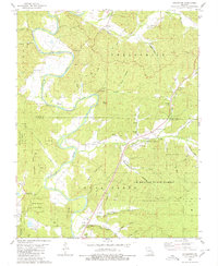
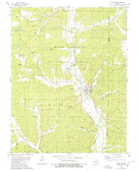 1980 Marquand1980 Print · USGSMarquand and the Castor River valley are captured here in the late seventies, showing a landscape of deep hollows within the Mark Twain National Forest. Researchers can trace family history through numerous rural landmarks like Stephens Cem, Rhodes Chapel, and the settlement of Klondike.2 unique versions available
 - 1980 Map of Cascade
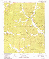 1980 Cascade1980 Print · USGSMadison and Wayne Counties are captured in the late seventies as rural life centered on the hollows and creek bottoms of the Ozarks. Genealogists and historians can trace family locations through numerous sites like Old Mt Pisgah Cem, Gravelton, and Zion Ch.
 - 1980 Map of Rock Pile Mountain
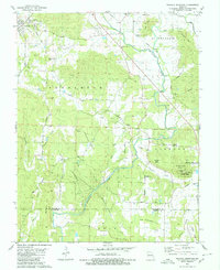
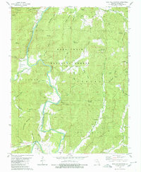 1980 Rock Pile Mountain1980 Print · USGSMadison County in the early eighties was a landscape of forested peaks and river valleys deeply etched by early settlement. Genealogists can trace family names through numerous burial sites like Shoemaker Cem and Berry Cem, or locate landmarks such as French Mills and Mt Pisgah Ch.
 - 1980 Map of Knob Lick
 1980 Knob Lick1980 Print · USGSIn the 1970s and 80s, these rural Missouri uplands were a mix of small crossroads settlements and family farms along the county lines. Researchers can trace local lineage through Wesley Chapel Cemetery and Sebastian Cemetery, or locate landmarks like Castle Rock and the S-F Scout Ranch.2 unique versions available
 - 1980 Map of Fredericktown
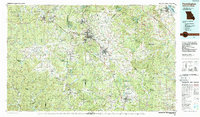
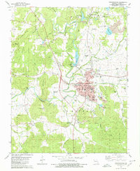 1980 Fredericktown1980 Print · USGSMadison County mining operations and rural settlements are shown here as they appeared in the late twentieth century. Researchers can locate numerous family cemeteries like Buckner Cem and trace historical workings at the Catherine Mine and Offset Mine.
 - 1980 Map of Wachita Mountain
 1980 Wachita Mountain1980 Print · USGSSoutheastern Missouri's mining and granite-quarrying heritage is on full display in this late-century survey of the St. Francois Mountains. Genealogists can trace family names at Doe Run Mem Cem and O'Bannon Cem or locate the Maeda Sch.2 unique versions available
 - 1980 Map of Rhodes Mountain
 1980 Rhodes Mountain1980 Print · USGSMadison and St. Francois counties in the early 1980s showcase a landscape defined by deep-woods mining and the river. Genealogists and historians can locate remote family sites like Ashlock Cem, the historic Einstein Mine, and the German Community Hall.2 unique versions available
 - 1980 Map of Allbright
 1980 Allbright1980 Print · USGSSoutheast Missouri's river country comes to life in this survey from the late seventies, showing the rural communities along the Castor River. Genealogists can trace family names at Rhodes Cem, Millers Chapel, and the isolated Ivy Cem.
 - 1980 Map of Coldwater
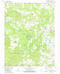
 1980 Coldwater1980 Print · USGSMadison and Wayne Counties in the 1980s show a landscape of deep hollows and family-held lands along the St Francis River. Researchers can trace old homesteads and rural landmarks like the Linville-Barrett Cem, Saco, and Oak Dale Ch.
 - 1986 Map of Piedmont
 1986 Piedmont1986 Print · USGSThe Missouri Ozarks are captured here in the mid-eighties as a region of dense state forests and critical river management. Genealogists and historians can trace family-named features and rural settlements like Piedmont, Lesterville, and the Yokum School.2 unique versions available
 - 1986 Map of Farmington
 1986 Farmington1986 Print · USGSThe Missouri Lead Belt and the eastern Ozarks are detailed here in the mid-1980s, showcasing a landscape of intensive mining and deep forest. Researchers can trace the Missouri Pacific RR line through industrial centers like Bonne Terre and Flat River, or locate remote landmarks like Elephant Rocks.
 - 1987 Map of Farmington
 1987 Farmington1987 Print · USGSThe St. Francois Mountains and Missouri Lead Belt are shown in the late eighties as industry and conservation converged. Researchers can trace the rail lines of the Missouri Pacific and locate historic mining sites like Mine La Motte and the Iron Mountain Mine.
 - 1989 Map of Rolla
 1989 Rolla1989 Print · USGSThe Missouri Ozarks are captured in the late eighties as a landscape of national forests and historic mining towns. Researchers can trace the rail lines of the Missouri Pacific RR or locate landmarks like Taum Sauk Mtn and Elephant Rocks State Park.
End of results
Showing maps 1-14 of 14
Top cities of Madison County
Frequently asked questions
- What are the different types of historical maps available for Madison County?
- What is the oldest map of Madison County?
- Where can I purchase historical maps of Madison County for my home or office?
- Where can I download high-res historical maps of Madison County?
- Are there historical topographic maps available for Madison County?
- Is there historical aerial imagery available for Madison County?
- Where are historical maps of Madison County sourced from?