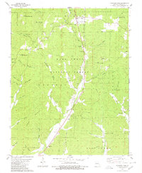
1980 Map of Cherokee Pass
USGS Topo · Published 1980About this map
Cherokee Pass and the surrounding timberlands of the Mark Twain National Forest define this 1980 survey of Madison County. The landscape is a network of ridges and deep hollows, such as Old Mines Hollow and Rock House Hollow, where small settlements and homesteads once clustered near dependable water sources like Lampher Spring and Twelvemile Creek. The map provides significant genealogical value through its many rural burial grounds, including the Revelle Cem and Settle Cem, which are often situated near country churches like Central Ch or Twelvemile Ch.
Find a feature on this map
67 named features on this map. Tap any name to fly to it.
Don’t see what you’re looking for? This feature index may not catch every label — zoom into the map to look around manually.
Map Details
Editions of this 1980 Cherokee Pass Map
This is the sole edition of this map. No revisions or reprints were ever made.
Other maps of this area

1910 · Higdon
USGS Topo · 1:62,500

1930 · Coldwater
USGS Topo · 1:62,500

1933 · Marquand
USGS Topo · 1:62,500

1938 · Marquand
USGS Topo · 1:62,500

1939 · Fredericktown
USGS Topo · 1:48,000

1947 · Fredericktown
USGS Topo · 1:62,500

1949 · Rolla
USGS Topo · 1:250,000

1949 · Coldwater
USGS Topo · 1:62,500

1950 · Fredericktown
USGS Topo · 1:62,500

1953 · Rolla
USGS Topo · 1:250,000