1960s Maps of Marion County, Missouri
Explore 2 historic maps of Marion County from the 1960s. These maps offer a rare glimpse into what life looked like during the 1960s — showing old roads, neighborhoods, homes, and landmarks that have changed or disappeared over time.
Whether you're researching your family's past, planning a metal detecting trip, or studying how Marion County's landscape evolved across the 1960s, these high-resolution maps are a powerful tool for exploring the history of this region.
- Focus on a specific era: All maps on this page are from the 1960s, giving you a focused view of this time period.
- See what’s changed: Compare century-old streets, trails, and buildings to today's modern landscape using overlays and satellite layers.
- Research with precision: Use these maps for genealogy, historical research, land use analysis, or educational projects.
- View, download, or print: Maps are fully viewable online in high resolution, and can be downloaded or printed for your own records.
Start exploring Marion County's history through authentic maps from the 1960s. This is your window into the past.
Marion County, MO maps
(2)- 1964 Map of Emden, 1965 Print
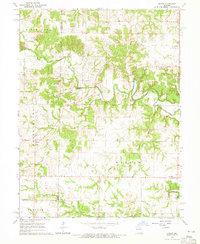 1964 Emden1965 Print · USGSMarion and Shelby counties are captured in the mid-1960s, showing a traditional Missouri landscape of river-bottom farms and quiet crossroads. Researchers can locate the Emden Sch, trace the winding North River, and find family sites near Andrew Chapel and Ebenezer Cem.2 unique versions available
 - 1964 Map of Nelsonville, 1965 Print
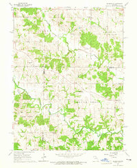 1964 Nelsonville1965 Print · USGSMarion County farming communities thrived in the mid-1960s along the winding banks of the South Fabius River. Genealogists and local historians can trace family locations near the settlement of Nelsonville and rural landmarks like Asbury Chapel or the Methodist Cem.
End of results
Showing maps 1-2 of 2
Top cities of Marion County
Frequently asked questions
- What are the different types of historical maps available for Marion County?
- What is the oldest map of Marion County?
- Where can I purchase historical maps of Marion County for my home or office?
- Where can I download high-res historical maps of Marion County?
- Are there historical topographic maps available for Marion County?
- Is there historical aerial imagery available for Marion County?
- Where are historical maps of Marion County sourced from?