1990s Maps of Marion County, Missouri
Explore 4 historic maps of Marion County from the 1990s. These maps offer a rare glimpse into what life looked like during the 1990s — showing old roads, neighborhoods, homes, and landmarks that have changed or disappeared over time.
Whether you're researching your family's past, planning a metal detecting trip, or studying how Marion County's landscape evolved across the 1990s, these high-resolution maps are a powerful tool for exploring the history of this region.
- Focus on a specific era: All maps on this page are from the 1990s, giving you a focused view of this time period.
- See what’s changed: Compare century-old streets, trails, and buildings to today's modern landscape using overlays and satellite layers.
- Research with precision: Use these maps for genealogy, historical research, land use analysis, or educational projects.
- View, download, or print: Maps are fully viewable online in high resolution, and can be downloaded or printed for your own records.
Start exploring Marion County's history through authentic maps from the 1990s. This is your window into the past.
Marion County, MO maps
(4)- 1993 Map of Hannibal East, 1996 Print
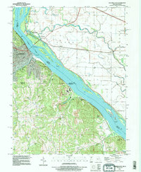 1993 Hannibal East1996 Print · USGSThe Mississippi River corridor near Hannibal comes to life in this mid-nineties survey of the Missouri-Illinois border. Genealogists and historians can trace Riverside Cem, the Mark Twain Cave, and old river settlements like Saverton and Monkey Run.
 - 1996 Map of Quincy West, 1997 Print
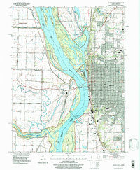 1996 Quincy West1997 Print · USGSThe riverfront at Quincy and the Illinois-Missouri border are captured here in the mid-1990s as the city expands along the eastern bluffs. Researchers can trace the river's complex island system, industrial mines, and local landmarks like St Boniface Cem and the Quincy Mem Bridge.
 - 1996 Map of Marblehead, 1998 Print
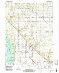 1996 Marblehead1998 Print · USGSThe Mississippi River bottomlands of Adams and Pike Counties are shown here in the 1990s as a landscape of levees and industrial quarries. Genealogists can trace family landmarks like Craigtown Cem and Bluff Hall while exploring the shifting banks of Schaffer Island.
 - 1996 Map of Quincy SW, 1998 Print
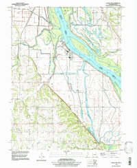 1996 Quincy SW1998 Print · USGSMarion County and the Illinois borderlands appear in the late nineties as a network of river-bound islands and upland cemeteries. Trace family roots at Thrasher Chapel or along the bluffs at Kaiser Cem and Cobb Cem.
End of results
Showing maps 1-4 of 4
Top cities of Marion County
Frequently asked questions
- What are the different types of historical maps available for Marion County?
- What is the oldest map of Marion County?
- Where can I purchase historical maps of Marion County for my home or office?
- Where can I download high-res historical maps of Marion County?
- Are there historical topographic maps available for Marion County?
- Is there historical aerial imagery available for Marion County?
- Where are historical maps of Marion County sourced from?