1980s Maps of Monroe County, Missouri
Explore 4 historic maps of Monroe County from the 1980s. These maps offer a rare glimpse into what life looked like during the 1980s — showing old roads, neighborhoods, homes, and landmarks that have changed or disappeared over time.
Whether you're researching your family's past, planning a metal detecting trip, or studying how Monroe County's landscape evolved across the 1980s, these high-resolution maps are a powerful tool for exploring the history of this region.
- Focus on a specific era: All maps on this page are from the 1980s, giving you a focused view of this time period.
- See what’s changed: Compare century-old streets, trails, and buildings to today's modern landscape using overlays and satellite layers.
- Research with precision: Use these maps for genealogy, historical research, land use analysis, or educational projects.
- View, download, or print: Maps are fully viewable online in high resolution, and can be downloaded or printed for your own records.
Start exploring Monroe County's history through authentic maps from the 1980s. This is your window into the past.
Monroe County, MO maps
(4)- 1981 Map of Macon
 1981 Macon1981 Print · USGSNorthern Missouri's rail-and-river landscape is captured here in the early eighties, centered on the crossroads of Macon. Researchers can trace old cemetery sites like St Marys Cem, local landmarks such as College Mound, and the routes of the Burlington Northern railroad.
 - 1985 Map of Moberly
 1985 Moberly1985 Print · USGSCentral Missouri in the mid-eighties shows a landscape of rail-connected towns and active resource extraction across Randolph and Howard Counties. Genealogists and historians can locate family landmarks like Sunset Hill Cem or trace the Norfolk and Western RR through Moberly and Salisbury.2 unique versions available
 - 1986 Map of Quincy
 1986 Quincy1986 Print · USGSThe tri-state border region along the Mississippi River comes into focus during the mid-1980s. Researchers can trace the legacy of river towns and rail hubs like Quincy and Monroe City or locate landmarks such as Mount Olive Cem.2 unique versions available
 - 1986 Map of Mexico
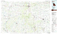
 1986 Mexico1986 Print · USGSEast Central Missouri in the mid-eighties shows a landscape of steady agricultural towns and the expansive waters of Mark Twain Lake. Genealogists and historians can trace rail-side communities like Laddonia and Wellsville or locate family markers at Elwood Cem.2 unique versions available
End of results
Showing maps 1-4 of 4
Top cities of Monroe County
- Paris historical maps
- Madison historical maps
- Holliday historical maps
- Stoutsville historical maps
- Goss historical maps
- Goss historical maps
Frequently asked questions
- What are the different types of historical maps available for Monroe County?
- What is the oldest map of Monroe County?
- Where can I purchase historical maps of Monroe County for my home or office?
- Where can I download high-res historical maps of Monroe County?
- Are there historical topographic maps available for Monroe County?
- Is there historical aerial imagery available for Monroe County?
- Where are historical maps of Monroe County sourced from?