1930s Maps of Morgan County, Missouri
Explore 9 historic maps of Morgan County from the 1930s. These maps offer a rare glimpse into what life looked like during the 1930s — showing old roads, neighborhoods, homes, and landmarks that have changed or disappeared over time.
Whether you're researching your family's past, planning a metal detecting trip, or studying how Morgan County's landscape evolved across the 1930s, these high-resolution maps are a powerful tool for exploring the history of this region.
- Focus on a specific era: All maps on this page are from the 1930s, giving you a focused view of this time period.
- See what’s changed: Compare century-old streets, trails, and buildings to today's modern landscape using overlays and satellite layers.
- Research with precision: Use these maps for genealogy, historical research, land use analysis, or educational projects.
- View, download, or print: Maps are fully viewable online in high resolution, and can be downloaded or printed for your own records.
Start exploring Morgan County's history through authentic maps from the 1930s. This is your window into the past.
Morgan County, MO maps
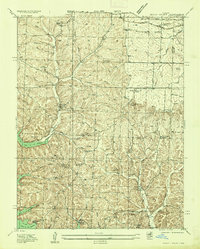
(9)- 1932 Map of Versailles No 4
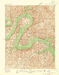
 1932 Versailles No 41932 Print · USGSThe Missouri Ozarks are captured here in the early 1930s, showing the early transformation of the landscape following the creation of Lake of the Ozarks. Researchers can trace the roots of Osage Beach or locate rural landmarks like Popplewell Cem and Watson Sch.
 - 1934 Map of Purvis
 1934 Purvis1934 Print · USGSThe Lake of the Ozarks shoreline was still finding its shape in the mid-1930s as tourism began to reshape the Missouri hills. Researchers can locate early recreational spots like Lakewood Club alongside rural landmarks like Stevens Cem and St Patricks Ch.2 unique versions available
 - 1934 Map of Irontown Ferry
 1934 Irontown Ferry1934 Print · USGSThe Lake of the Ozarks had only recently reached its full capacity when this 1930s survey was conducted along the Camden County line. Genealogists and researchers can trace the locations of the Irontown Ferry, the Old Iron Smelter, and early schools like Clark Sch.2 unique versions available
 - 1934 Map of Lake Ozark
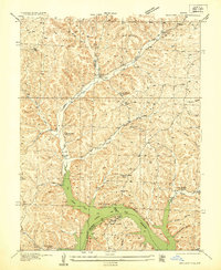
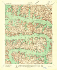 1934 Lake Ozark1934 Print · USGSThe new reservoir era in Central Missouri comes to life in this survey, showing the shoreline just after the completion of Bagnell Dam. Researchers can trace the early developments at Lakeview Beach and locate rural landmarks like Harpers Chapel and Zebra PO.3 unique versions available
 - 1935 Map of Gravois Mills
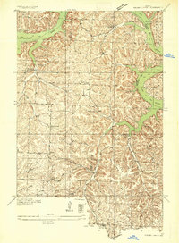
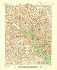 1935 Gravois Mills1935 Print · USGSThe northern reaches of the Lake of the Ozarks are captured here in the mid-1930s as tourism begins to reshape Morgan County. Researchers can trace early resort life at YMCA Camp and Navaho Beach or locate family home sites near Jacobs Sch and Gravois Mills.
 - 1935 Map of Proctor Creek
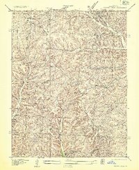 1935 Proctor Creek1935 Print · USGSMorgan County is documented here during the mid-1930s, showing the rural uplands just as the Lake of the Ozarks was reshaping the southern landscape. Genealogists can locate family landmarks such as Richey Church and several community schools like Lindoff School and Saw Mill School.
 - 1935 Map of Rocky Mount
 1935 Rocky Mount1935 Print · USGSThe Morgan and Miller County borderlands are shown here in the mid-1930s as the northern arms of the Lake of the Ozarks began to shape the terrain. Researchers can locate rural landmarks like the Stover Coal Bank, the Rocky Mount PO, and several family cemeteries.
 - 1935 Map of Boylers Mill
 1935 Boylers Mill1935 Print · USGSThe Morgan and Benton county lines meet here in the 1930s, showing the early impact of the newly formed Lake of the Ozarks. Genealogists can trace family landmarks like the Shiloh Church, Boylers Mill, and several rural one-room schoolhouses.
 - 1935 Map of Knobby Creek
 1935 Knobby Creek1935 Print · USGSThe northern Lake of the Ozarks shoreline and its surrounding uplands appear here in the mid-1930s as the reservoir era began. Genealogists can trace rural school districts like Olive Branch School and Nickel Hill School or locate family sites near Dority Cem and Sagrada.2 unique versions available
End of results
Showing maps 1-9 of 9
Top cities of Morgan County
- Versailles historical maps
- Stover historical maps
- Laurie historical maps
- Barnett historical maps
- Gravois Mills historical maps
- Syracuse historical maps
Frequently asked questions
- What are the different types of historical maps available for Morgan County?
- What is the oldest map of Morgan County?
- Where can I purchase historical maps of Morgan County for my home or office?
- Where can I download high-res historical maps of Morgan County?
- Are there historical topographic maps available for Morgan County?
- Is there historical aerial imagery available for Morgan County?
- Where are historical maps of Morgan County sourced from?