1950s Maps of Morgan County, Missouri
Explore 21 historic maps of Morgan County from the 1950s. These maps offer a rare glimpse into what life looked like during the 1950s — showing old roads, neighborhoods, homes, and landmarks that have changed or disappeared over time.
Whether you're researching your family's past, planning a metal detecting trip, or studying how Morgan County's landscape evolved across the 1950s, these high-resolution maps are a powerful tool for exploring the history of this region.
- Focus on a specific era: All maps on this page are from the 1950s, giving you a focused view of this time period.
- See what’s changed: Compare century-old streets, trails, and buildings to today's modern landscape using overlays and satellite layers.
- Research with precision: Use these maps for genealogy, historical research, land use analysis, or educational projects.
- View, download, or print: Maps are fully viewable online in high resolution, and can be downloaded or printed for your own records.
Start exploring Morgan County's history through authentic maps from the 1950s. This is your window into the past.
Morgan County, MO maps
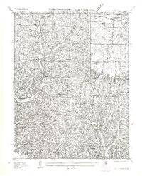
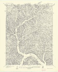
(21)- 1951 Map of Latham, 1954 Print
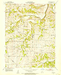 1951 Latham1954 Print · USGSMid-Missouri farming life in the early fifties is preserved here, centered on the village of Latham. Genealogists and historians can trace family roots through numerous rural landmarks like Latham Cem, Pilot Grove Ch, and the many namesake schools like Pilot Sch.2 unique versions available
 - 1952 Map of Tipton, 1953 Print
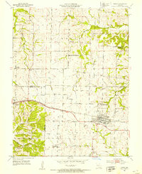 1952 Tipton1953 Print · USGSTipton and Syracuse sit at the junction of Cooper, Morgan, and Moniteau counties during the early fifties rail era. Researchers can trace the sprawling campus of the State Industrial Home for Girls or locate several decommissioned schools like Glendale Sch.3 unique versions available
 - 1952 Map of Fortuna, 1953 Print
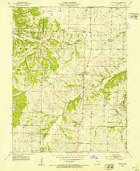 1952 Fortuna1953 Print · USGSMoniteau and Morgan counties are shown in the early fifties, capturing a network of rural schools and family cemeteries. Trace the locations of historic local institutions like St Martins Sch, Hickory Grove Sch, and the Prairie View Ch.3 unique versions available
 - 1953 Map of Florence, 1954 Print
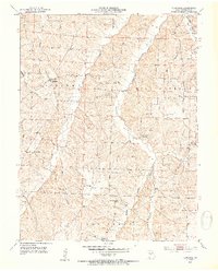 1953 Florence1954 Print · USGSMorgan County, Missouri, is captured here in the early fifties during a period of rural consolidation. Researchers can trace ancestral locations through numerous country schools and cemeteries like Bluhm Sch, Lone Star Sch, and Bethlehem Cem.3 unique versions available
 - 1953 Map of Otterville East, 1954 Print
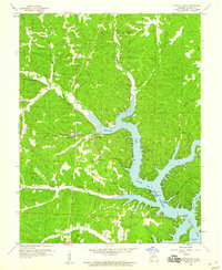
 1953 Otterville East1954 Print · USGSMid-century Morgan and Cooper counties appear here as a landscape of rural townships and river valleys. Researchers can trace family history at Antioch Cem and Mt Olive Ch or follow the Missouri Pacific rail line through Otterville.3 unique versions available
 - 1954 Map of Jefferson City
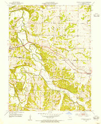
 1954 Jefferson City1954 Print · USGSCentral Missouri in the early postwar years showcases a landscape defined by the winding Lake of the Ozarks and the state capital at Jefferson City. Researchers can trace the mid-century rail networks of the Missouri Pacific RR and locate rural communities like Tuscumbia, St Elizabeth, and St Anthony.2 unique versions available
 - 1955 Map of Jefferson City, 1967 Print
 1955 Jefferson City1967 Print · USGSCentral Missouri in the mid-fifties is defined by the winding Missouri River and the expanding reach of Lake of the Ozarks. Researchers can trace the rail corridors of the Missouri Pacific or locate the early footprint of Whiteman AFB and Jefferson City.4 unique versions available
 - 1957 Map of Rocky Mount
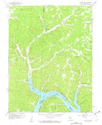
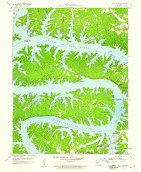
 1957 Rocky Mount1957 Print · USGSCentral Missouri hill country meets the rising waters of the lake in the mid-1930s. Genealogists and historians can locate old landmarks like Barnett Sta, the Stover Coal Bank, and small country burial grounds such as Dooley Cem.
 - 1957 Map of Proctor Creek
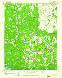
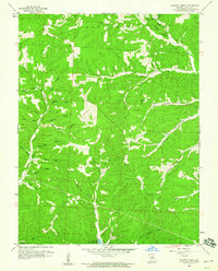
 1957 Proctor Creek1957 Print · USGSMorgan County is documented here during the mid-1930s, showing the rural landscape as the nearby reservoir began to reshape the region. Researchers can locate early country schools like Locust School and Lindoff School, the Kidney Church, and the settlement of Bowers.
 - 1957 Map of Gravois Mills
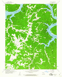
 1957 Gravois Mills1957 Print · USGSMorgan County is captured during the mid-century when the shoreline of the Gravois Arm Lake of the Ozarks was still maturing. Genealogists and local historians can locate Hale Sch, the YMCA Camp, and landmarks like Washburn Point.
 - 1957 Map of Boylers Mill
 1957 Boylers Mill1957 Print · USGSIn the mid-thirties, this part of the Missouri Ozarks centered on the waters of the newly formed lake and the valleys of Boylers Mill. Genealogists can locate family landmarks like Big Buffalo School, Shiloh Church, and the site of Zachada Ferry.
 - 1958 Map of Jefferson City
 1958 Jefferson City1958 Print · USGSCentral Missouri in the late fifties shows a region transforming through the growth of Whiteman Air Force Base and the Lake of the Ozarks. Researchers can trace rail lines like the Missouri Pacific or find family roots at Enloe Cemetery and Mount Pleasant Cem.
 - 1959 Map of Jefferson City
 1959 Jefferson City1959 Print · USGSCentral Missouri is captured during the mid-fifties as the river economy and rail networks like the Missouri Pacific met the rise of the automobile. Local researchers can trace family landmarks and rural infrastructure from the Lake of the Ozarks up to Providence Cemetery and Knob Noster State Park.
 - 1959 Map of Boylers Mill, 1960 Print
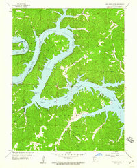
 1959 Boylers Mill1960 Print · USGSThe Morgan and Benton County line in the late fifties shows the intersection of traditional Ozark creek valleys and the expanding Lake of the Ozarks. Genealogists and local historians can trace rural landmarks like Boylers Mill, Big Buffalo Sch, and Mt Calvary Ch.2 unique versions available
 - 1959 Map of Rocky Mount, 1960 Print
 1959 Rocky Mount1960 Print · USGSThe northern reaches of the Lake of the Ozarks are captured here in the late fifties as the reservoir reshaped the Morgan County landscape. Genealogists and researchers can trace family landmarks like the Taylor Cem, Union Ch, and the defunct Stover Mine.2 unique versions available
 - 1959 Map of Knobby, 1960 Print
 1959 Knobby1960 Print · USGSCamden County and the surrounding Ozarks are captured here in the late fifties, showing the intricate shoreline and rural communities of the region. Researchers can trace family roots at Lick Creek Church, the Dandy Cemetery, and small crossroads like Sagrada.2 unique versions available
 - 1959 Map of Proctor Creek, 1960 Print
 1959 Proctor Creek1960 Print · USGSMorgan County's rugged creek valleys and early shoreline developments at the Lake of the Ozarks are captured here in the late fifties. Genealogists and local historians can locate Proctor Cem, Locust Ch, and family landmarks like Spangler Hollow.2 unique versions available
 - 1959 Map of Gravois Mills, 1960 Print
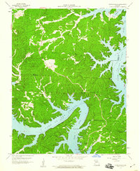
 1959 Gravois Mills1960 Print · USGSThe Lake of the Ozarks shoreline near Gravois Mills was well-established by the late fifties, blending traditional Ozark hollows with new lakeside recreation. Genealogists and local historians can locate St Patrick Ch, the Mitchell Mine, and landmarks like Jacobs Cave.3 unique versions available
 - 1959 Map of Sunrise Beach, 1960 Print
 1959 Sunrise Beach1960 Print · USGSThe Lake of the Ozarks shoreline in the late fifties shows a landscape of growing lakeside communities and deep-rooted rural landmarks. Researchers can trace family history at St Patricks Ch or locate the Hurricane Deck Lookout Tower and Stevens Cem.3 unique versions available
 - 1959 Map of Bollinger Creek, 1960 Print
 1959 Bollinger Creek1960 Print · USGSThe Lake of the Ozarks shoreline in the late fifties shows the dramatic transformation of the Osage River valley into a major reservoir system. Genealogists and local historians can trace family locations through Parish Cem, Wilson Cem, and landmarks like Thornsberry Point.3 unique versions available
 - 1959 Map of Lake Ozark, 1960 Print
 1959 Lake Ozark1960 Print · USGSThe Lake of the Ozarks shoreline is captured here in the late fifties, showing the growth of Lake Ozark near the Bagnell Dam. Researchers can locate family landmarks such as Stevens Banner Cem, Harpers Chapel, and the School of the Osage.3 unique versions available
End of results
Showing maps 1-21 of 21
Top cities of Morgan County
- Versailles historical maps
- Stover historical maps
- Laurie historical maps
- Barnett historical maps
- Gravois Mills historical maps
- Syracuse historical maps
Frequently asked questions
- What are the different types of historical maps available for Morgan County?
- What is the oldest map of Morgan County?
- Where can I purchase historical maps of Morgan County for my home or office?
- Where can I download high-res historical maps of Morgan County?
- Are there historical topographic maps available for Morgan County?
- Is there historical aerial imagery available for Morgan County?
- Where are historical maps of Morgan County sourced from?