1930s Maps of Pulaski County, Missouri
Explore 3 historic maps of Pulaski County from the 1930s. These maps offer a rare glimpse into what life looked like during the 1930s — showing old roads, neighborhoods, homes, and landmarks that have changed or disappeared over time.
Whether you're researching your family's past, planning a metal detecting trip, or studying how Pulaski County's landscape evolved across the 1930s, these high-resolution maps are a powerful tool for exploring the history of this region.
- Focus on a specific era: All maps on this page are from the 1930s, giving you a focused view of this time period.
- See what’s changed: Compare century-old streets, trails, and buildings to today's modern landscape using overlays and satellite layers.
- Research with precision: Use these maps for genealogy, historical research, land use analysis, or educational projects.
- View, download, or print: Maps are fully viewable online in high resolution, and can be downloaded or printed for your own records.
Start exploring Pulaski County's history through authentic maps from the 1930s. This is your window into the past.
Pulaski County, MO maps
(3)- 1933 Map of Iberia, 1963 Print
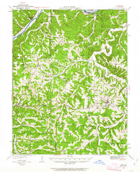 1933 Iberia1963 Print · USGSThe Osage River hills during the early 1930s reveal a landscape of isolated farmsteads and rural schoolhouses. Genealogists can trace family roots through numerous sites like Ramsey Cem, Gott Ch, and vanished school districts like Stumpf Sch.2 unique versions available
 - 1936 Map of Waynesville
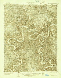 1936 Waynesville1936 Print · USGSPulaski County during the mid-1930s is defined by its winding river valleys and the expansion of the Gardner National Forest. Researchers can trace ancestral locations through an extensive network of rural landmarks, including the Old Indian Lead Mine, Riddle Bridge, and the Sweet Home Ch.
 - 1937 Map of Iberia
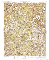 1937 Iberia1937 Print · USGSIberia and the surrounding Miller County hills are captured here in the mid-1930s, showing a landscape of small farms and crossroads communities. Genealogists can trace family footprints at Ramsey Cem, Twelve Corners Ch, and dozens of rural school sites like Barton Sch.2 unique versions available
End of results
Showing maps 1-3 of 3
Top cities of Pulaski County
- Saint Robert historical maps
- Waynesville historical maps
- Richland historical maps
- Dixon historical maps
- Crocker historical maps
Frequently asked questions
- What are the different types of historical maps available for Pulaski County?
- What is the oldest map of Pulaski County?
- Where can I purchase historical maps of Pulaski County for my home or office?
- Where can I download high-res historical maps of Pulaski County?
- Are there historical topographic maps available for Pulaski County?
- Is there historical aerial imagery available for Pulaski County?
- Where are historical maps of Pulaski County sourced from?