1970s Maps of Pulaski County, Missouri
Explore 4 historic maps of Pulaski County from the 1970s. These maps offer a rare glimpse into what life looked like during the 1970s — showing old roads, neighborhoods, homes, and landmarks that have changed or disappeared over time.
Whether you're researching your family's past, planning a metal detecting trip, or studying how Pulaski County's landscape evolved across the 1970s, these high-resolution maps are a powerful tool for exploring the history of this region.
- Focus on a specific era: All maps on this page are from the 1970s, giving you a focused view of this time period.
- See what’s changed: Compare century-old streets, trails, and buildings to today's modern landscape using overlays and satellite layers.
- Research with precision: Use these maps for genealogy, historical research, land use analysis, or educational projects.
- View, download, or print: Maps are fully viewable online in high resolution, and can be downloaded or printed for your own records.
Start exploring Pulaski County's history through authentic maps from the 1970s. This is your window into the past.
Pulaski County, MO maps
(4)- 1976 Map of Waynesville, 1980 Print
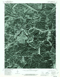 1976 Waynesville1980 Print · USGSWaynesville and St Robert appear in detailed aerial photography during the mid-seventies as the region continued to develop around the military installation. Researchers can trace land use patterns near Fort Leonard Wood and follow the natural curves of the Gasconade River.
 - 1976 Map of Big Piney, 1980 Print
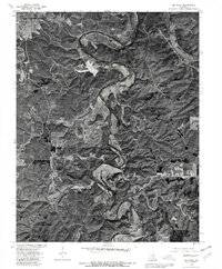 1976 Big Piney1980 Print · USGSThe Ozark highlands of Pulaski County appear in sharp detail in the mid-1970s, showcasing the winding Big Piney River and the northern presence of Fort Leonard Wood. Researchers can trace rural road networks and land use around the settlements of Big Piney and Duke.
 - 1976 Map of Devils Elbow, 1980 Print
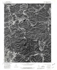 1976 Devils Elbow1980 Print · USGSPulaski County’s river valleys and the edges of a major military installation are seen here during the mid-seventies. Trace the sharp bends of the Gasconade River and find old settlements like Hooker and the distinctive meander at Devils Elbow.
 - 1976 Map of Bloodland, 1980 Print
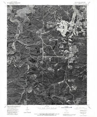 1976 Bloodland1980 Print · USGSThe Ozark highlands of Pulaski County are revealed in this mid-seventies aerial study of the Bloodland area. Researchers can trace the winding course of Roubidoux Creek and see the early development footprint of Fort Leonard Wood.
End of results
Showing maps 1-4 of 4
Top cities of Pulaski County
- Saint Robert historical maps
- Waynesville historical maps
- Richland historical maps
- Dixon historical maps
- Crocker historical maps
Frequently asked questions
- What are the different types of historical maps available for Pulaski County?
- What is the oldest map of Pulaski County?
- Where can I purchase historical maps of Pulaski County for my home or office?
- Where can I download high-res historical maps of Pulaski County?
- Are there historical topographic maps available for Pulaski County?
- Is there historical aerial imagery available for Pulaski County?
- Where are historical maps of Pulaski County sourced from?