1960s Maps of Putnam County, Missouri
Explore 4 historic maps of Putnam County from the 1960s. These maps offer a rare glimpse into what life looked like during the 1960s — showing old roads, neighborhoods, homes, and landmarks that have changed or disappeared over time.
Whether you're researching your family's past, planning a metal detecting trip, or studying how Putnam County's landscape evolved across the 1960s, these high-resolution maps are a powerful tool for exploring the history of this region.
- Focus on a specific era: All maps on this page are from the 1960s, giving you a focused view of this time period.
- See what’s changed: Compare century-old streets, trails, and buildings to today's modern landscape using overlays and satellite layers.
- Research with precision: Use these maps for genealogy, historical research, land use analysis, or educational projects.
- View, download, or print: Maps are fully viewable online in high resolution, and can be downloaded or printed for your own records.
Start exploring Putnam County's history through authentic maps from the 1960s. This is your window into the past.
Putnam County, MO maps
(4)- 1964 Map of Pollock NW, 1965 Print
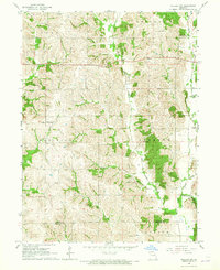 1964 Pollock NW1965 Print · USGSPutnam and Sullivan Counties are shown here in the mid-1960s, a period of quiet agricultural stability along the West Locust Creek valley. Genealogists can locate rural landmarks like West Concord Ch, Spring Cem, and the small settlement of Terre Haute.
 - 1964 Map of Unionville West, 1965 Print
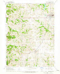 1964 Unionville West1965 Print · USGSPutnam County's rural landscape is captured here in the mid-1960s, showing the agricultural and transport networks that defined the region. You can trace the Chicago Burlington and Quincy rail line through Lemons and locate local landmarks like Triumph Sch and Cutter Cem.2 unique versions available
 - 1964 Map of Lucerne, 1965 Print
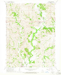 1964 Lucerne1965 Print · USGSThe rural landscape of Putnam County comes into focus in the mid-1960s, showing a region defined by its rail connections and creek-bottom farms. Researchers can trace family history through the Old Busby Cem, West Putnam Sch, and the village of Lucerne.
 - 1964 Map of Powersville, 1966 Print
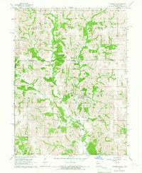 1964 Powersville1966 Print · USGSThe Missouri-Iowa borderlands come to life in the mid-sixties, centered on the railroad village of Powersville. Genealogists can trace local roots across numerous burial sites like Wyreka Cem, Edmond Cem, and the tracks of the Milwaukee Road.
End of results
Showing maps 1-4 of 4
Top cities of Putnam County
- Unionville historical maps
- Livonia historical maps
- Lucerne historical maps
- Worthington historical maps
- Powersville historical maps
Frequently asked questions
- What are the different types of historical maps available for Putnam County?
- What is the oldest map of Putnam County?
- Where can I purchase historical maps of Putnam County for my home or office?
- Where can I download high-res historical maps of Putnam County?
- Are there historical topographic maps available for Putnam County?
- Is there historical aerial imagery available for Putnam County?
- Where are historical maps of Putnam County sourced from?