1970s Maps of Town and Country, Missouri
Explore 2 historic maps of Town and Country from the 1970s. These maps offer a rare glimpse into what life looked like during the 1970s — showing old roads, neighborhoods, homes, and landmarks that have changed or disappeared over time.
Whether you're researching your family's past, planning a metal detecting trip, or studying how Town and Country's landscape evolved across the 1970s, these high-resolution maps are a powerful tool for exploring the history of this region.
- Focus on a specific era: All maps on this page are from the 1970s, giving you a focused view of this time period.
- See what’s changed: Compare century-old streets, trails, and buildings to today's modern landscape using overlays and satellite layers.
- Research with precision: Use these maps for genealogy, historical research, land use analysis, or educational projects.
- View, download, or print: Maps are fully viewable online in high resolution, and can be downloaded or printed for your own records.
Start exploring Town and Country's history through authentic maps from the 1970s. This is your window into the past.
Town and Country, MO maps
(2)- 1979 Map of Chesterfield, 1981 Print
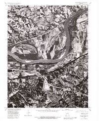 1979 Chesterfield1981 Print · USGSSt. Louis County and St. Charles County are captured during a period of suburban transition in the late seventies. Researchers can trace the development of Chesterfield and Bellefontaine or study the agricultural bottomlands near Howell.
 - 1979 Map of Manchester, 1981 Print
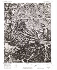 1979 Manchester1981 Print · USGSWestern St. Louis County suburban expansion is captured here in the late seventies as residential tracts fill the space between established towns. Trace the streets of Times Beach or the riverfront of Valley Park along the Meramec River.
End of results
Showing maps 1-2 of 2
Top cities near Town and Country
- O'Fallon historical maps
- Saint Charles historical maps
- Saint Peters historical maps
- Florissant historical maps
- Chesterfield historical maps
- Oakville historical maps
See more
Frequently asked questions
- What are the different types of historical maps available for Town and Country?
- What is the oldest map of Town and Country?
- Where can I purchase historical maps of Town and Country for my home or office?
- Where can I download high-res historical maps of Town and Country?
- Are there historical topographic maps available for Town and Country?
- Is there historical aerial imagery available for Town and Country?
- Where are historical maps of Town and Country sourced from?