1950s Maps of Town and Country, Missouri
Explore 4 historic maps of Town and Country from the 1950s. These maps offer a rare glimpse into what life looked like during the 1950s — showing old roads, neighborhoods, homes, and landmarks that have changed or disappeared over time.
Whether you're researching your family's past, planning a metal detecting trip, or studying how Town and Country's landscape evolved across the 1950s, these high-resolution maps are a powerful tool for exploring the history of this region.
- Focus on a specific era: All maps on this page are from the 1950s, giving you a focused view of this time period.
- See what’s changed: Compare century-old streets, trails, and buildings to today's modern landscape using overlays and satellite layers.
- Research with precision: Use these maps for genealogy, historical research, land use analysis, or educational projects.
- View, download, or print: Maps are fully viewable online in high resolution, and can be downloaded or printed for your own records.
Start exploring Town and Country's history through authentic maps from the 1950s. This is your window into the past.
Town and Country, MO maps
(4)- 1954 Map of Kirkwood, 1959 Print
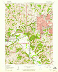 1954 Kirkwood1959 Print · USGSPost-war St. Louis County suburbs expand across the Meramec River valley in the mid-fifties as new neighborhoods surround historic rail lines. Genealogists can trace family roots at Marshall Cem or explore sites like Weiss Airport and Ursuline Academy.7 unique versions available
 - 1954 Map of Creve Coeur, 1959 Print
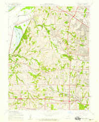 1954 Creve Coeur1959 Print · USGSMid-century St. Louis County is caught at a moment of rapid suburban transformation as new expressways begin to carve through historic townships. Genealogists and local historians can trace family-named landmarks, parish schools like St Monica Sch, and established sites such as Mt Lebanon Cem and Maryland Heights.7 unique versions available
 - 1954 Map of Manchester, 1959 Print
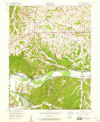 1954 Manchester1959 Print · USGSThe Meramec valley and western St. Louis County are seen here in the mid-fifties, during a period of suburban expansion and industrial utility. Genealogists can locate family landmarks like Lewis Cem, the Oak Ridge Sch (Abandoned), and the original platting of Times Beach.8 unique versions available
 - 1954 Map of Chesterfield, 1959 Print
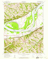 1954 Chesterfield1959 Print · USGSIn the mid-fifties, the Missouri River bluffs supported a mix of riverside industry and historic rural centers. Genealogists and local historians can trace the footprint of Gumbo, Chesterfield, and Bellefontaine before the modern expansion, locating landmarks like St Thomas Ch and the Chicago and Pacific rail line.5 unique versions available
End of results
Showing maps 1-4 of 4
Top cities near Town and Country
- O'Fallon historical maps
- Saint Charles historical maps
- Saint Peters historical maps
- Florissant historical maps
- Chesterfield historical maps
- Oakville historical maps
See more
Frequently asked questions
- What are the different types of historical maps available for Town and Country?
- What is the oldest map of Town and Country?
- Where can I purchase historical maps of Town and Country for my home or office?
- Where can I download high-res historical maps of Town and Country?
- Are there historical topographic maps available for Town and Country?
- Is there historical aerial imagery available for Town and Country?
- Where are historical maps of Town and Country sourced from?