1980s Maps of St. Clair County, Missouri
Explore 6 historic maps of St. Clair County from the 1980s. These maps offer a rare glimpse into what life looked like during the 1980s — showing old roads, neighborhoods, homes, and landmarks that have changed or disappeared over time.
Whether you're researching your family's past, planning a metal detecting trip, or studying how St. Clair County's landscape evolved across the 1980s, these high-resolution maps are a powerful tool for exploring the history of this region.
- Focus on a specific era: All maps on this page are from the 1980s, giving you a focused view of this time period.
- See what’s changed: Compare century-old streets, trails, and buildings to today's modern landscape using overlays and satellite layers.
- Research with precision: Use these maps for genealogy, historical research, land use analysis, or educational projects.
- View, download, or print: Maps are fully viewable online in high resolution, and can be downloaded or printed for your own records.
Start exploring St. Clair County's history through authentic maps from the 1980s. This is your window into the past.
St. Clair County, MO maps
(6)- 1980 Map of Warsaw West, 1982 Print
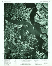 1980 Warsaw West1982 Print · USGSBenton County undergoes a massive transformation in the 1980s as the Osage River valley is inundated. Trace the new shoreline of the Harry S Truman Reservoir and locate local landmarks like Warsaw, Wisdom, and Tackner.
 - 1981 Map of Butler
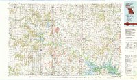 1981 Butler1981 Print · USGSWestern Missouri and eastern Kansas settlements are documented here in the early eighties, as the river valleys were transitioning into major wildlife management areas. Genealogists can locate family names near Greenlawn Cem or trace the development of towns like Butler, Osawatomie, and Appleton City.
 - 1981 Map of Appleton City, 1982 Print
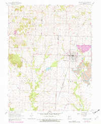 1981 Appleton City1982 Print · USGSAppleton City and the surrounding rural townships of Bates and St. Clair counties are shown here during the early eighties. Genealogists and local historians can locate several burial grounds like Fennewald Cem and trace the Missouri Kansas Texas rail line through Lindale.
 - 1983 Map of Harry S Truman Reservoir, 1984 Print
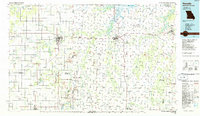
 1983 Harry S Truman Reservoir1984 Print · USGSBenton and Henry counties center on the vast Harry S Truman Reservoir in the early 1980s as the landscape adapted to its new shoreline. Genealogists and historians can trace old river crossings like Bledsoe Ferry, local landmarks like Mt Zion Ch, and unique settlements such as Tightwad.
 - 1984 Map of Bolivar
 1984 Bolivar1984 Print · USGSWestern Missouri in the mid-eighties shows a landscape shaped by large-scale water management and rail commerce. Genealogists and historians can trace the development of towns like Bolivar and El Dorado Springs alongside the massive Stockton Lake.
 - 1986 Map of Nevada
 1986 Nevada1986 Print · USGSThe Missouri-Kansas borderlands in the mid-1980s show a landscape of active rail lines and coal mining. Researchers can trace the Old Military Road or locate family plots in the National Cemetery and Deepwood Cemetery.
End of results
Showing maps 1-6 of 6
Top cities of St. Clair County
- Appleton City historical maps
- Osceola historical maps
- Lowry City historical maps
- Collins historical maps
- Roscoe historical maps
- Vista historical maps
See more
Frequently asked questions
- What are the different types of historical maps available for St. Clair County?
- What is the oldest map of St. Clair County?
- Where can I purchase historical maps of St. Clair County for my home or office?
- Where can I download high-res historical maps of St. Clair County?
- Are there historical topographic maps available for St. Clair County?
- Is there historical aerial imagery available for St. Clair County?
- Where are historical maps of St. Clair County sourced from?