1990s Maps of St. Clair County, Missouri
Explore 16 historic maps of St. Clair County from the 1990s. These maps offer a rare glimpse into what life looked like during the 1990s — showing old roads, neighborhoods, homes, and landmarks that have changed or disappeared over time.
Whether you're researching your family's past, planning a metal detecting trip, or studying how St. Clair County's landscape evolved across the 1990s, these high-resolution maps are a powerful tool for exploring the history of this region.
- Focus on a specific era: All maps on this page are from the 1990s, giving you a focused view of this time period.
- See what’s changed: Compare century-old streets, trails, and buildings to today's modern landscape using overlays and satellite layers.
- Research with precision: Use these maps for genealogy, historical research, land use analysis, or educational projects.
- View, download, or print: Maps are fully viewable online in high resolution, and can be downloaded or printed for your own records.
Start exploring St. Clair County's history through authentic maps from the 1990s. This is your window into the past.
St. Clair County, MO maps
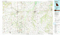
(16)- 1991 Map of Vista
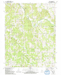
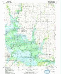
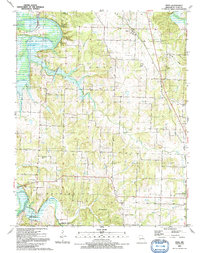 1991 Vista1991 Print · USGSIn the early 1990s, this area of St. Clair County shows a rural landscape shaped by the Harry S Truman Reservoir and the Sac River. Researchers can trace numerous family burial sites like Macedonia Cem and Roberts Cem or locate the Old Railroad Grade near Vista.
 - 1991 Map of Tiffin
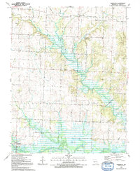
 1991 Tiffin1991 Print · USGSIn the early nineties, the borderlands of St. Clair and Cedar counties maintained a quiet rural character defined by the winding Osage River. Researchers can trace historic family landmarks from Tiffin to Cedar Springs, including Landers Cem and Pape Ch.
 - 1991 Map of Monegaw Springs
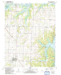
 1991 Monegaw Springs1991 Print · USGSSt. Clair County's river valley and rural uplands are shown in detail during the early nineties. Genealogists and historians can trace family locations through Terry Cem, Cooks Chapel, and the historic namesake community at Monegaw Springs.
 - 1991 Map of Ninnescah Park
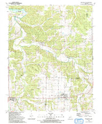
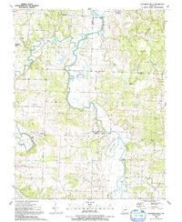
 1991 Ninnescah Park1991 Print · USGSThe Harry S Truman Reservoir reshaped the Missouri river valleys in the late twentieth century, creating a labyrinth of water and timber. Genealogists and local historians can locate early burial grounds like Peaceful Home Cem and settlements such as Leesville and Finey.
 - 1991 Map of Weaubleau
 1991 Weaubleau1991 Print · USGSLife along the Hickory and St. Clair county line in the early nineties centered on small agricultural hubs and creek valleys. Genealogists and historians can trace the Old Railroad Grade past Gerster or locate the Robinson Cem and Kings Prairie Ch.
 - 1991 Map of El Dorado Springs North
 1991 El Dorado Springs North1991 Print · USGSThe rural borderlands of Cedar and St. Clair counties are documented here in the early nineties as El Dorado Springs expanded. Genealogists and historians can locate family landmarks like Lefler Cem, Portia, and the old Railroad Grade.
 - 1991 Map of Arnica
 1991 Arnica1991 Print · USGSCedar County in the early nineties remains a landscape of rural crossroads and wildlife conservation areas. Genealogists and local historians can trace family locations near Williams Store, Sneak Cem, and community churches like Brush Creek Ch.
 - 1991 Map of Iconium
 1991 Iconium1991 Print · USGSSt. Clair County's rugged borderlands met the rising waters of the reservoir during the early nineties. Researchers can trace rural life at Iconium or find old community centers like Bear Creek Ch and the H Roe Bartle Scout Reservation.
 - 1991 Map of Roscoe
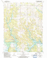
 1991 Roscoe1991 Print · USGSThe river bottoms of St. Clair County are captured here in the early nineties as the Osage and Sac Rivers meet. Genealogists and local historians can trace family names and rural landmarks like Love Mound Cem, the Pasley Landing Strip, and the settlement of Crooks Springs.
 - 1991 Map of Osceola
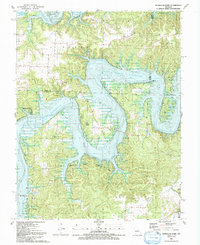
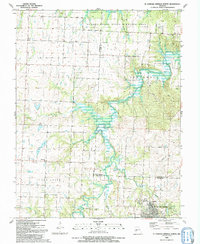
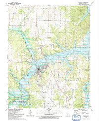 1991 Osceola1991 Print · USGSIn the early 1990s, Osceola was a riverfront community defined by the rising waters of the Harry S Truman Reservoir. Genealogists and researchers can trace local family roots through sites like Dunkard Cem, High Hill Ch, and the Old RR Grade.
 - 1991 Map of Caplinger Mills
 1991 Caplinger Mills1991 Print · USGSCedar County life in the early nineties centers on the winding Sac River and the community at Caplinger Mills. Local researchers can trace family landmarks like Leila Store, Hackleman Cem, and several rural churches including Mt Zion Ch.
 - 1991 Map of Rockville
 1991 Rockville1991 Print · USGSThe Osage River bottomlands near the Bates and Vernon county line define this late-century landscape. Genealogists and local historians can locate the Rockville Cem, explore the extensive Schell-Osage Wildlife Area, and trace the winding course of Panther Creek.
 - 1991 Map of Humansville
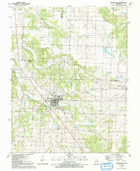 1991 Humansville1991 Print · USGSThe Polk County countryside near Humansville is shown here in the early nineties, centered on a landscape of prairie and creek valleys. Researchers can trace family history through numerous local sites like Flemington Cem, Rondo, and the Old Railroad Grade.
 - 1991 Map of Nevada
 1991 Nevada1991 Print · USGSThis borderland region in the early nineties captures the transition from Kansas plains to Missouri timber. Researchers can trace family history through Bunn Cemetery, locate the Camp Clark Military Reservation, and explore rail towns like Nevada and Fort Scott.
 - 1991 Map of Taberville, 1992 Print
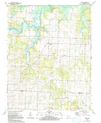
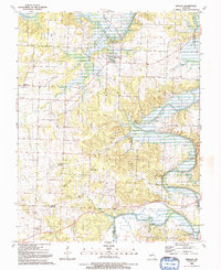
 1991 Taberville1992 Print · USGSSt. Clair County in the early 1990s shows a quiet landscape of river bends and rural crossroads along the Osage River. Genealogists and historians can trace family ties at sites like Johnson City, Harmony Ch, and numerous small burial grounds including Daller Cem and Good Cem.
 - 1991 Map of Lowry City, 1992 Print
 1991 Lowry City1992 Print · USGSThe shorelines of the Truman Reservoir met the rolling Missouri prairie in the early nineties, reshaping the area around Lowry City and Brownington. Genealogists and historians can trace defunct transport lines like the Old Railroad Grade and locate local landmarks such as Park Grove Ch and Maplewood Cemetery.
End of results
Showing maps 1-16 of 16
Top cities of St. Clair County
- Appleton City historical maps
- Osceola historical maps
- Lowry City historical maps
- Collins historical maps
- Roscoe historical maps
- Vista historical maps
See more
Frequently asked questions
- What are the different types of historical maps available for St. Clair County?
- What is the oldest map of St. Clair County?
- Where can I purchase historical maps of St. Clair County for my home or office?
- Where can I download high-res historical maps of St. Clair County?
- Are there historical topographic maps available for St. Clair County?
- Is there historical aerial imagery available for St. Clair County?
- Where are historical maps of St. Clair County sourced from?