1960s Maps of St. Clair County, Missouri
Explore 5 historic maps of St. Clair County from the 1960s. These maps offer a rare glimpse into what life looked like during the 1960s — showing old roads, neighborhoods, homes, and landmarks that have changed or disappeared over time.
Whether you're researching your family's past, planning a metal detecting trip, or studying how St. Clair County's landscape evolved across the 1960s, these high-resolution maps are a powerful tool for exploring the history of this region.
- Focus on a specific era: All maps on this page are from the 1960s, giving you a focused view of this time period.
- See what’s changed: Compare century-old streets, trails, and buildings to today's modern landscape using overlays and satellite layers.
- Research with precision: Use these maps for genealogy, historical research, land use analysis, or educational projects.
- View, download, or print: Maps are fully viewable online in high resolution, and can be downloaded or printed for your own records.
Start exploring St. Clair County's history through authentic maps from the 1960s. This is your window into the past.
St. Clair County, MO maps
(5)- 1960 Map of Monegaw Springs NW, 1962 Print
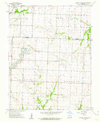 1960 Monegaw Springs NW1962 Print · USGSSt. Clair and Henry counties appear in the early sixties as a landscape of rural townships and emerging industrial sites. Genealogists and historians can trace local landmarks from Teays Chapel and Harmony Cem to the early Strip Mine operations.3 unique versions available
 - 1961 Map of Lawrence
 1961 Lawrence1961 Print · USGSThe Kansas-Missouri borderland shows its mid-century transition from a rail-dependent agricultural region to a suburbanizing landscape. Genealogists can trace family footprints through numerous Cem sites and distinctive terrain landmarks like Graves Mound and Summers Mound.
 - 1961 Map of Ohio, 1962 Print
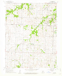 1961 Ohio1962 Print · USGSThe transition from small-town farming to heavy resource extraction is evident in this St. Clair County landscape during the early sixties. Genealogists and historians can trace rural roots through landmarks like Ohio, the Valley Center School, and Westfield Cemetery.2 unique versions available
 - 1961 Map of Appleton City, 1962 Print
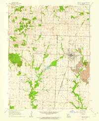 1961 Appleton City1962 Print · USGSAppleton City in the early sixties was a bustling rail town defined by the diagonal transit of the Missouri Kansas Texas railroad. Genealogists and local historians can locate rural landmarks like the Hudson School, Fennewald Cemetery, and the extensive strip mining fields to the east.
 - 1965 Map of Warsaw West, 1966 Print
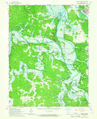 1965 Warsaw West1966 Print · USGSBenton County was entering a period of major environmental change in the mid-1960s as preparations for a new reservoir began. Genealogists and local historians can trace threatened landmarks like Fairfield, Wisdom Cem, and the Freedom Sch before the landscape was altered.4 unique versions available
End of results
Showing maps 1-5 of 5
Top cities of St. Clair County
- Appleton City historical maps
- Osceola historical maps
- Lowry City historical maps
- Collins historical maps
- Roscoe historical maps
- Vista historical maps
See more
Frequently asked questions
- What are the different types of historical maps available for St. Clair County?
- What is the oldest map of St. Clair County?
- Where can I purchase historical maps of St. Clair County for my home or office?
- Where can I download high-res historical maps of St. Clair County?
- Are there historical topographic maps available for St. Clair County?
- Is there historical aerial imagery available for St. Clair County?
- Where are historical maps of St. Clair County sourced from?