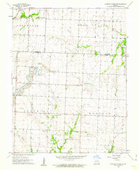
1960 Map of Monegaw Springs NW
USGS Topo · Published 1962About this map
The Missouri-Kansas-Texas railroad cuts through the northwestern corner of this landscape, crossing Bear Creek as it passes near the prominent landform known as The Mound. This 1960 era survey reveals a rural landscape in transition, characterized by the extensive footprint of a Strip Mine in the western reaches and a small Landing Strip nearby. These industrial and transportation features contrast with the established agricultural patterns of the Deepwater and Appleton townships. Local social centers are anchored by Marshall and the Community Hall, while spiritual and commemorative sites like Teays Chapel and Harmony Cem provide critical points of interest for genealogists. The drainage network, featuring Ricky Creek and Ditty Creek, defines the lower topography south of Golden Ridge.
Find a feature on this map
22 named features on this map. Tap any name to fly to it.
Don’t see what you’re looking for? This feature index may not catch every label — zoom into the map to look around manually.
Map Details
Editions of this 1960 Monegaw Springs NW Map
3 editions found
Other maps of this area

1887 · Clinton
USGS Topo · 1:125,000

1887 · Butler
USGS Topo · 1:125,000

1894 · Butler
USGS Topo · 1:125,000

1894 · Clinton
USGS Topo · 1:125,000

1934 · Rockville
USGS Topo · 1:24,000

1938 · Monegaw Springs
USGS Topo · 1:24,000

1938 · Taberville
USGS Topo · 1:24,000

1940 · Taberville
USGS Topo · 1:24,000
1940 · Monegaw Springs
USGS Topo · 1:24,000

1947 · Jefferson City
USGS Topo · 1:250,000