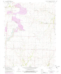
1960 Map of Monegaw Springs NW
USGS Topo · Published 1982About this map
Industrial land use and rural settlement patterns intersect across the borders of Henry and St. Clair Counties in this mid-century survey. Large-scale Strip Mine operations dominate the northwestern landscape, with substantial areas designated as Reclaimed Area indicating the early stages of post-mining environmental recovery. This industrial activity contrasts sharply with the established agrarian community structures evidenced by scattered landmarks like Tenya Chapel, Harmony Cem, and the Community Hall.
Find a feature on this map
22 named features on this map. Tap any name to fly to it.
Don’t see what you’re looking for? This feature index may not catch every label — zoom into the map to look around manually.
Map Details
Editions of this 1960 Monegaw Springs NW Map
3 editions found
Other maps of this area

1887 · Clinton
USGS Topo · 1:125,000

1887 · Butler
USGS Topo · 1:125,000

1894 · Butler
USGS Topo · 1:125,000

1894 · Clinton
USGS Topo · 1:125,000

1934 · Rockville
USGS Topo · 1:24,000

1938 · Monegaw Springs
USGS Topo · 1:24,000

1938 · Taberville
USGS Topo · 1:24,000

1940 · Taberville
USGS Topo · 1:24,000
1940 · Monegaw Springs
USGS Topo · 1:24,000

1947 · Jefferson City
USGS Topo · 1:250,000