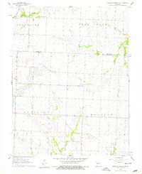
1960 Map of Monegaw Springs NW
USGS Topo · Published 1979About this map
Strip mining activity defines the industrial footprint along the western edge of the St. Clair and Henry County line as documented in 1960. These excavations, accompanied by a dedicated Landing Strip, contrast with the rural agricultural patterns found across Appleton and Monegaw townships. The landscape is characterized by intermittent drainage like Bear Creek and Tricky Creek, which cut through the terrain near local landmarks such as The Mound. Local community life is anchored by traditional rural institutions, including the Community Hall and Teays Chapel in the northeast. Genealogists can find primary burial locations at Harmony Cem and other smaller cemeteries scattered across the township sections. The map reveals the intersection of resource extraction and established farming settlements during the mid-century era.
Find a feature on this map
22 named features on this map. Tap any name to fly to it.
Don’t see what you’re looking for? This feature index may not catch every label — zoom into the map to look around manually.
Map Details
Editions of this 1960 Monegaw Springs NW Map
3 editions found
Other maps of this area

1887 · Clinton
USGS Topo · 1:125,000

1887 · Butler
USGS Topo · 1:125,000

1894 · Butler
USGS Topo · 1:125,000

1894 · Clinton
USGS Topo · 1:125,000

1934 · Rockville
USGS Topo · 1:24,000

1938 · Monegaw Springs
USGS Topo · 1:24,000

1938 · Taberville
USGS Topo · 1:24,000

1940 · Taberville
USGS Topo · 1:24,000
1940 · Monegaw Springs
USGS Topo · 1:24,000

1947 · Jefferson City
USGS Topo · 1:250,000