1900s (20th Century) Maps of LaValle, Missouri
Explore 5 historic maps of LaValle from the 1900s (20th Century). These maps offer a rare glimpse into what life looked like during the 1900s — showing old roads, neighborhoods, homes, and landmarks that have changed or disappeared over time.
Whether you're researching your family's past, planning a metal detecting trip, or studying how LaValle's landscape evolved across the 1900s, these high-resolution maps are a powerful tool for exploring the history of this region.
- Focus on a specific era: All maps on this page are from the 1900s, giving you a focused view of this time period.
- See what’s changed: Compare century-old streets, trails, and buildings to today's modern landscape using overlays and satellite layers.
- Research with precision: Use these maps for genealogy, historical research, land use analysis, or educational projects.
- View, download, or print: Maps are fully viewable online in high resolution, and can be downloaded or printed for your own records.
Start exploring LaValle's history through authentic maps from the 1900s. This is your window into the past.
LaValle, MO maps
(5)- 1940 Map of Malden, 1942 Print
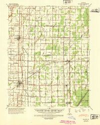 1940 Malden1942 Print · USGSIn the Missouri Bootheel during the early 1940s, a vast network of drainage ditches transformed the landscape for farming and rail commerce. Researchers can trace rural life through dozens of named landmarks like Sugar Tree Ch & Sch, Stephenson Cem, and Tallapoosa.
 - 1956 Map of Malden
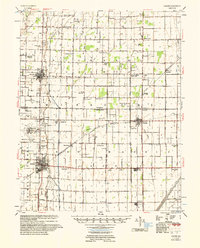 1956 Malden1956 Print · USGSThe Missouri bootheel in the mid-1950s reveals a highly engineered landscape where drainage ditches and rail lines shaped every town and farm. Genealogists can locate family landmarks like Poplin Sch & Cem, Stones Chapel Cem, and the Malden Air Force Base.
 - 1956 Map of Dyersburg, 1960 Print
 1956 Dyersburg1960 Print · USGSThe Four Rivers region comes alive in the mid-fifties, capturing the intricate borderlands of Tennessee, Kentucky, and Missouri. Genealogists and historians can trace the rail-and-river networks connecting Dyersburg, Caruthersville, and the shoreline of Reelfoot Lake.4 unique versions available
 - 1978 Map of Hills Store, 1979 Print
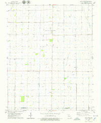 1978 Hills Store1979 Print · USGSStoddard and New Madrid counties are mapped here during the late seventies, showing a landscape defined by drainage canals and the Castor River. Genealogists and historians can trace family roots at Stones Chapel Cem or locate the old town site of La Valle along a former rail route.
 - 1985 Map of Sikeston, 1986 Print
 1985 Sikeston1986 Print · USGSThe Missouri Bootheel and the four-state river convergence are captured in the mid-eighties as the modern agricultural and rail networks matured. Researchers can locate regional landmarks like the Towosahgy State Historic Site, Oak Grove Cem, and towns along the St Louis Southwestern Railroad.2 unique versions available
End of results
Showing maps 1-5 of 5
Top cities near LaValle
- Sikeston historical maps
- Dexter historical maps
- Malden historical maps
- New Madrid historical maps
- Bloomfield historical maps
- Bernie historical maps
See more
Frequently asked questions
- What are the different types of historical maps available for LaValle?
- What is the oldest map of LaValle?
- Where can I purchase historical maps of LaValle for my home or office?
- Where can I download high-res historical maps of LaValle?
- Are there historical topographic maps available for LaValle?
- Is there historical aerial imagery available for LaValle?
- Where are historical maps of LaValle sourced from?