1970s Maps of Innsbrook, Missouri
Explore 2 historic maps of Innsbrook from the 1970s. These maps offer a rare glimpse into what life looked like during the 1970s — showing old roads, neighborhoods, homes, and landmarks that have changed or disappeared over time.
Whether you're researching your family's past, planning a metal detecting trip, or studying how Innsbrook's landscape evolved across the 1970s, these high-resolution maps are a powerful tool for exploring the history of this region.
- Focus on a specific era: All maps on this page are from the 1970s, giving you a focused view of this time period.
- See what’s changed: Compare century-old streets, trails, and buildings to today's modern landscape using overlays and satellite layers.
- Research with precision: Use these maps for genealogy, historical research, land use analysis, or educational projects.
- View, download, or print: Maps are fully viewable online in high resolution, and can be downloaded or printed for your own records.
Start exploring Innsbrook's history through authentic maps from the 1970s. This is your window into the past.
Innsbrook, MO maps
(2)- 1972 Map of Wright City, 1974 Print
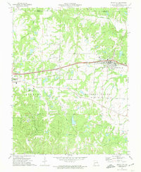 1972 Wright City1974 Print · USGSWright City and Truesdale are shown at a crossroads of rail and regional industry in the early seventies. Trace the Norfolk and Western line or locate local landmarks like Passionist Fathers Seminary and Harmonie Ch.2 unique versions available
 - 1972 Map of Marthasville, 1975 Print
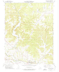 1972 Marthasville1975 Print · USGSMarthasville and the fertile river bottoms of Warren County come to life in the early 1970s as the rail-and-river economy persists. Genealogists and historians can locate rural landmarks like Peers, the Missouri - Kansas - Texas rail line, and numerous claypits.2 unique versions available
End of results
Showing maps 1-2 of 2
Top cities near Innsbrook
- Wentzville historical maps
- Washington historical maps
- Troy historical maps
- Warrenton historical maps
- Wright City historical maps
- Moscow Mills historical maps
See more
Frequently asked questions
- What are the different types of historical maps available for Innsbrook?
- What is the oldest map of Innsbrook?
- Where can I purchase historical maps of Innsbrook for my home or office?
- Where can I download high-res historical maps of Innsbrook?
- Are there historical topographic maps available for Innsbrook?
- Is there historical aerial imagery available for Innsbrook?
- Where are historical maps of Innsbrook sourced from?