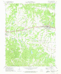
1972 Map of Wright City
USGS Topo · Published 1974About this map
Wright City and the neighboring settlement of Truesdale anchor this 1970s survey, highlighting the transport and education hubs of eastern Missouri. The Norfolk and Western rail line cuts a straight path across the terrain, passing through the heart of the developed areas. Educational and religious history is represented by the Passionist Fathers Seminary, while the northern portion of the map reveals a rural landscape marked by family names like Graves and Klausmeier. To the south, the terrain transitions into the dense woodlands of Reifsnider State Forest, an area characterized by numerous claypits and a quarry, indicating the local extraction industry. Waterways like Hickory Lick Creek and Peruque Creek drain the surrounding hills, which are crisscrossed by a network of local thoroughfares such as Stuerman Road and Strack Church Road.
Find a feature on this map
45 named features on this map. Tap any name to fly to it.
Don’t see what you’re looking for? This feature index may not catch every label — zoom into the map to look around manually.
Map Details
Editions of this 1972 Wright City Map
2 editions found
Other maps of this area

1890 · Hermann
USGS Topo · 1:125,000

1903 · O'Fallon
USGS Topo · 1:125,000

1941 · Troy
USGS Topo · 1:62,500

1943 · Warrenton
USGS Topo · 1:62,500

1945 · Troy
USGS Topo · 1:62,500

1945 · Warrenton
USGS Topo · 1:62,500

1948 · Washington
USGS Topo · 1:62,500

1948 · Augusta
USGS Topo · 1:62,500

1949 · Saint Louis
USGS Topo · 1:250,000
1949 · Washington
USGS Topo · 1:62,500