1980s Maps of Washington County, Missouri
Explore 12 historic maps of Washington County from the 1980s. These maps offer a rare glimpse into what life looked like during the 1980s — showing old roads, neighborhoods, homes, and landmarks that have changed or disappeared over time.
Whether you're researching your family's past, planning a metal detecting trip, or studying how Washington County's landscape evolved across the 1980s, these high-resolution maps are a powerful tool for exploring the history of this region.
- Focus on a specific era: All maps on this page are from the 1980s, giving you a focused view of this time period.
- See what’s changed: Compare century-old streets, trails, and buildings to today's modern landscape using overlays and satellite layers.
- Research with precision: Use these maps for genealogy, historical research, land use analysis, or educational projects.
- View, download, or print: Maps are fully viewable online in high resolution, and can be downloaded or printed for your own records.
Start exploring Washington County's history through authentic maps from the 1980s. This is your window into the past.
Washington County, MO maps
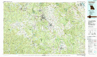
(12)- 1981 Map of Richwoods
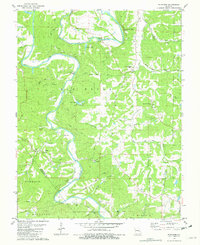
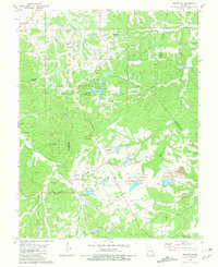 1981 Richwoods1981 Print · USGSRichwoods and the tri-county border area come alive in this early 1980s survey, showing the deep integration of mining and rural life. Researchers can trace family roots at St Stephens Cem, explore the extensive Richwoods Tailings Ponds, or locate the Joan Lake Landing Strip.
 - 1981 Map of Old Mines
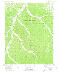
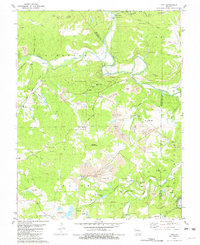
 1981 Old Mines1981 Print · USGSWashington County enters the 1980s with its mining heritage and rugged river valleys on full display. Genealogists and local historians can locate the Higginbotham Cem, trace the Missouri Pacific rail line, or find old landmarks like Clifton School.
 - 1981 Map of Ebo
 1981 Ebo1981 Print · USGSThe Missouri Ozarks of the early eighties reveal a landscape of deep hollows and active mining operations. Researchers can trace the Missouri Pacific line to the Indian Creek Mine or locate old burials at Smith Cem and Souls Chapel.
 - 1981 Map of Cyclone Hollow
 1981 Cyclone Hollow1981 Print · USGSThe rugged interior of Franklin and Washington Counties is captured here in the early eighties as a landscape of timber and quiet homesteads. Researchers can trace the California Trail or locate family markers at New Chapel Hill Cem and New Hope Cem.
 - 1981 Map of Fletcher, 1982 Print
 1981 Fletcher1982 Print · USGSJefferson County in the late seventies and early eighties was a landscape of river bends and rural crossroads. Local historians can trace family roots at McCain Cem, locate the site of Grandview Sch, or study the river crossings at Browns Ford Road.
 - 1981 Map of Tiff, 1982 Print
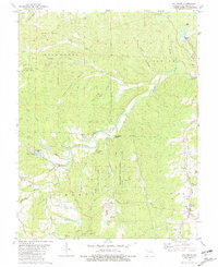
 1981 Tiff1982 Print · USGSNear the confluence of the Big River and Mineral Fork in the early eighties, this survey captures a landscape of intense mineral extraction and rural community. Genealogists and local historians can locate several family cemeteries and old school sites like Cruise Sch, St Joseph Cem, and Cannon Mines.
 - 1985 Map of Sullivan
 1985 Sullivan1985 Print · USGSMid-1980s Missouri comes into focus here as the Ozark landscape balances industrial mining with river recreation. Genealogists and historians can trace the St Louis-San Francisco RR through Sullivan and locate landmarks like Pea Ridge Mine or St Cloud Church.3 unique versions available
 - 1985 Map of Festus, 1987 Print
 1985 Festus1987 Print · USGSThe Mississippi River corridor and Ozark foothills appear here in the mid-1980s, documenting a landscape of industrial river towns and forest preserves. Trace the development of Festus, Crystal City, and De Soto or locate sites like Mastodon State Park.
 - 1986 Map of Rolla
 1986 Rolla1986 Print · USGSThe Missouri Ozarks are captured here in the mid-1980s, showcasing the intersection of deep forest wilderness and growing highway corridors. Genealogists and local historians can trace family roots through rural landmarks like Salem Memorial Cemetery or the rail-stop history of Cook Station and Steelville.2 unique versions available
 - 1986 Map of Farmington
 1986 Farmington1986 Print · USGSThe Missouri Lead Belt and the eastern Ozarks are detailed here in the mid-1980s, showcasing a landscape of intensive mining and deep forest. Researchers can trace the Missouri Pacific RR line through industrial centers like Bonne Terre and Flat River, or locate remote landmarks like Elephant Rocks.
 - 1987 Map of Farmington
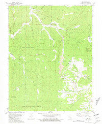
 1987 Farmington1987 Print · USGSThe St. Francois Mountains and Missouri Lead Belt are shown in the late eighties as industry and conservation converged. Researchers can trace the rail lines of the Missouri Pacific and locate historic mining sites like Mine La Motte and the Iron Mountain Mine.
 - 1989 Map of Rolla
 1989 Rolla1989 Print · USGSThe Missouri Ozarks are captured in the late eighties as a landscape of national forests and historic mining towns. Researchers can trace the rail lines of the Missouri Pacific RR or locate landmarks like Taum Sauk Mtn and Elephant Rocks State Park.
End of results
Showing maps 1-12 of 12
Top cities of Washington County
- Potosi historical maps
- Irondale historical maps
- Mineral Point historical maps
- Caledonia historical maps
Frequently asked questions
- What are the different types of historical maps available for Washington County?
- What is the oldest map of Washington County?
- Where can I purchase historical maps of Washington County for my home or office?
- Where can I download high-res historical maps of Washington County?
- Are there historical topographic maps available for Washington County?
- Is there historical aerial imagery available for Washington County?
- Where are historical maps of Washington County sourced from?