1900-1909 Maps of Washington County, Missouri
Explore 4 historic maps of Washington County from 1900-1909. These maps offer a rare glimpse into what life looked like during the 1900s — showing old roads, neighborhoods, homes, and landmarks that have changed or disappeared over time.
Whether you're researching your family's past, planning a metal detecting trip, or studying how Washington County's landscape evolved across the 1900s, these high-resolution maps are a powerful tool for exploring the history of this region.
- Focus on a specific era: All maps on this page are from the 1900s, giving you a focused view of this time period.
- See what’s changed: Compare century-old streets, trails, and buildings to today's modern landscape using overlays and satellite layers.
- Research with precision: Use these maps for genealogy, historical research, land use analysis, or educational projects.
- View, download, or print: Maps are fully viewable online in high resolution, and can be downloaded or printed for your own records.
Start exploring Washington County's history through authentic maps from the 1900s. This is your window into the past.
Washington County, MO maps
(4)- 1901 Map of De Soto
 1901 De Soto1901 Print · USGSJefferson and Franklin Counties at the turn of the century show a landscape defined by industrial milling and river fords. Genealogists can trace early homesteads near Hillsboro or industrial sites like Vulcan Mine and Byrnes Mill.5 unique versions available
 - 1903 Map of Sullivan
 1903 Sullivan1903 Print · USGSFranklin and Gasconade counties are captured here at the close of the nineteenth century, as the St. Louis and San Francisco railroad spurred growth in timber and mining. Genealogists can trace early homesteads and river crossings like Hughes Ford, Spring Bluff, and Anthonies Mill.3 unique versions available
 - 1905 Map of Bonneterre
 1905 Bonneterre1905 Print · USGSEastern Missouri's Lead Belt comes into focus during its industrial peak at the turn of the century. Genealogists and rail historians can trace the intricate connections between Bonneterre, Desloge, and Bismarck along the Mississippi River and Bonneterre RR.3 unique versions available
 - 1906 Map of Potosi
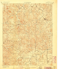 1906 Potosi1906 Print · USGSWashington County at the start of the century shows a landscape of Ozark creek bottoms and rail-connected towns. Genealogists and historians can trace old homesteads and landmarks near Potosi, Hunters Mill, and the community of Caledonia.3 unique versions available
End of results
Showing maps 1-4 of 4
Top cities of Washington County
- Potosi historical maps
- Irondale historical maps
- Mineral Point historical maps
- Caledonia historical maps
Frequently asked questions
- What are the different types of historical maps available for Washington County?
- What is the oldest map of Washington County?
- Where can I purchase historical maps of Washington County for my home or office?
- Where can I download high-res historical maps of Washington County?
- Are there historical topographic maps available for Washington County?
- Is there historical aerial imagery available for Washington County?
- Where are historical maps of Washington County sourced from?