1960s Maps of Wayne County, Missouri
Explore 23 historic maps of Wayne County from the 1960s. These maps offer a rare glimpse into what life looked like during the 1960s — showing old roads, neighborhoods, homes, and landmarks that have changed or disappeared over time.
Whether you're researching your family's past, planning a metal detecting trip, or studying how Wayne County's landscape evolved across the 1960s, these high-resolution maps are a powerful tool for exploring the history of this region.
- Focus on a specific era: All maps on this page are from the 1960s, giving you a focused view of this time period.
- See what’s changed: Compare century-old streets, trails, and buildings to today's modern landscape using overlays and satellite layers.
- Research with precision: Use these maps for genealogy, historical research, land use analysis, or educational projects.
- View, download, or print: Maps are fully viewable online in high resolution, and can be downloaded or printed for your own records.
Start exploring Wayne County's history through authentic maps from the 1960s. This is your window into the past.
Wayne County, MO maps
(23)- 1960 Map of Poplar Bluff
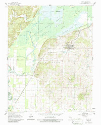
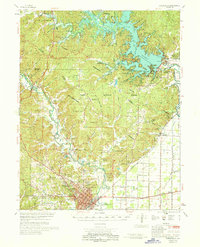
 1960 Poplar Bluff1960 Print · USGSSoutheast Missouri and Northeast Arkansas are captured here during the post-war era, showing the transition from the Ozark highlands to the Delta. Genealogists and historians can trace rail corridors like the St. Louis Southwestern RR and remote settlements such as Birch Tree and Warm Springs.
 - 1960 Map of Rolla
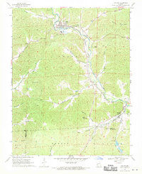
 1960 Rolla1960 Print · USGSThe Ozark Highlands in the mid-twentieth century reveal a landscape of deep timber and heavy industry. Researchers can trace the rail-and-mine economy through the St Louis-San Francisco RR and the Iron Mountain Mine, alongside the growth of Fort Leonard Wood.
 - 1962 Map of Puxico, 1963 Print
 1962 Puxico1963 Print · USGSThe southeast Missouri lowlands and the edge of the Ozarks are captured here during the early sixties, showing a landscape defined by drainage engineering and wildlife conservation. Genealogists and historians can trace family locations near Puxico, Asherville, and rural gathering places like Egypt Church or Gravel Hill Cemetery.3 unique versions available
 - 1963 Map of Gipsy, 1964 Print
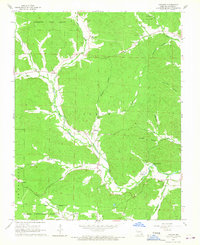
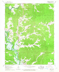
 1963 Gipsy1964 Print · USGSBollinger and Wayne counties appear here in the early sixties, centered on the winding path of the Castor River. Researchers can locate rural schools and churches such as Lower Turkey Creek Sch, Cowan Ch, and Maddox Cem.2 unique versions available
 - 1963 Map of McGee, 1964 Print
 1963 McGee1964 Print · USGSIn the early 1960s, the McGee area of Wayne County was a landscape of small rural congregations and remote cemeteries. Researchers can trace family history through sites like Mt Pleasant Cem, Wilfong Cem, and the McGee Sch.2 unique versions available
 - 1963 Map of Sturdivant, 1964 Print
 1963 Sturdivant1964 Print · USGSBollinger County and the edge of the Mingo wetlands are captured here in the early sixties as a landscape of river sloughs and quiet rail stops. Researchers can trace family history through sites like Sturdivant Cem, Kinder Chapel, and the small settlement of Arab.2 unique versions available
 - 1964 Map of Gipsy, 1985 Print
 1964 Gipsy1985 Print · USGSBollinger and Wayne Counties are captured in the mid-1960s as the river-cut landscape supported small settlements and timberlands. Genealogists can trace family names at Maddox Cem, Buchanan, and the Lower Turkey Creek Sch.
 - 1965 Map of Lowndes, 1967 Print
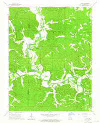
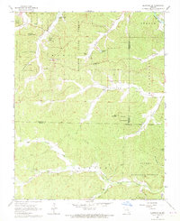
 1965 Lowndes1967 Print · USGSWayne County saw a network of small valley settlements and forest boundaries in the mid-sixties, long before modern development changed the rural landscape. Trace local roots through family-named sites like Graham Cem, the Hiram Sch, and the community at Lowndes.3 unique versions available
 - 1966 Map of Rolla
 1966 Rolla1966 Print · USGSThe Missouri Ozarks are revealed here in the mid-1960s, showing the intersection of heavy industry and sprawling national forests. Trace the development of the Lead Belt near Flat River or locate family roots in vanished hamlets like Enough and Howes Mill.
 - 1966 Map of Hendrickson, 1967 Print
 1966 Hendrickson1967 Print · USGSSoutheast Missouri’s river country is captured here in the mid-sixties as the forest and rail lines defined local life. Genealogists and historians can locate numerous remote burial sites like Military Crossing Cem and Keele Cem or trace the old Missouri Pacific tracks.
 - 1966 Map of Shook, 1967 Print
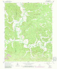
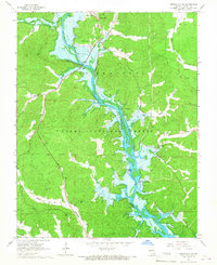
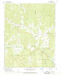
 1966 Shook1967 Print · USGSWayne County during the mid-sixties reveals a landscape defined by the rising waters of the St. Francis River basin and deep forest tracts. Researchers can locate family sites like Thornton Cemetery and Jones Cemetery or trace the old roads through Shook and McGee.2 unique versions available
 - 1966 Map of Wappapello, 1967 Print
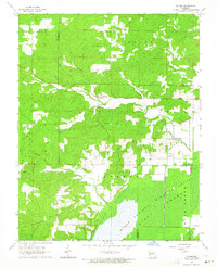
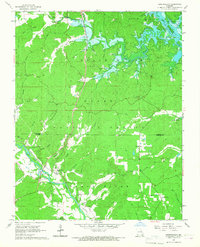
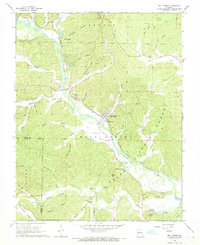
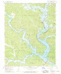
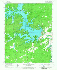 1966 Wappapello1967 Print · USGSWayne County during the mid-sixties reveals a landscape transformed by the waters of Lake Wappapello and the St Francis River. Genealogists and local historians can trace the sites of Chaonia, the Kelly Cem, and the University of Missouri Forestry Camp Lookout Tower.2 unique versions available
 - 1966 Map of Greenville, 1967 Print
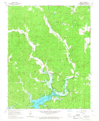
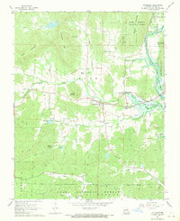
 1966 Greenville1967 Print · USGSThe Ozark foothills near the St. Francois River are captured in the mid-1960s as the river feeds into Lake Wappapello. Genealogists can trace family names at Tidwell Cem and Vavak Cem, or locate rural landmarks like White Hollow Sch and the community of Silva.3 unique versions available
 - 1966 Map of Greenville SW, 1967 Print
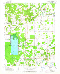
 1966 Greenville SW1967 Print · USGSWayne County saw significant changes in the 1960s as Lake Wappapello shaped the local geography near Greenville. Family historians can trace numerous remote burial sites like Pleasant Valley Cem and Stephens Cem or locate the site of Kime Ch.2 unique versions available
 - 1967 Map of Piedmont SE, 1969 Print
 1967 Piedmont SE1969 Print · USGSWayne County terrain in the late sixties reveals a network of timberlands and river valleys managed under the Clark National Forest. Genealogists can trace numerous family burial sites and rural congregations, including Meadors Cem, Eads Creek Cem, and Mt Pleasant Ch.
 - 1968 Map of Ellington SE, 1969 Print
 1968 Ellington SE1969 Print · USGSSoutheast Missouri in the late sixties reveals a landscape of state and national forests at the intersection of Carter and Reynolds counties. Genealogists can trace family roots through several remote burial sites like Bozarth Cem and Potter Cem, or locate the Devils Kitchen Mine.2 unique versions available
 - 1968 Map of Brunot, 1969 Print
 1968 Brunot1969 Print · USGSThe rural hills of Iron and Wayne counties are captured here in the late sixties as the local landscape remained deeply tied to its branching creek valleys. Genealogists and researchers can locate several remote burial sites such as Brewington Cem and Hunter Cem or trace the boundaries of Sam A Baker State Park.3 unique versions available
 - 1968 Map of Piedmont, 1969 Print
 1968 Piedmont1969 Print · USGSThe railroad town of Piedmont and the neighboring community of Beckville are captured here during the late sixties. Genealogists and local historians can trace family landmarks like the Diesel-Moore and Anderson cemeteries or the Beulah and Peachtree churches.2 unique versions available
 - 1968 Map of Mill Spring, 1969 Print
 1968 Mill Spring1969 Print · USGSThe Black River valley and the rugged interior of the Mark Twain National Forest are captured here in the late sixties. Researchers can trace genealogies through numerous small burial grounds and rural landmarks like Leeper Cem, Shady Nook Ch, and the Missouri Pacific River rail line.2 unique versions available
 - 1968 Map of Patterson, 1969 Print
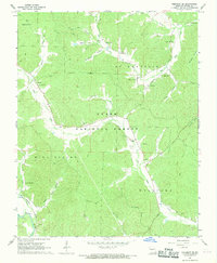
 1968 Patterson1969 Print · USGSWayne County, Missouri, is captured here in the late sixties, showcasing the rugged terrain surrounding Patterson and the St. Francis River. Genealogists and historians can locate numerous family burial sites and rural landmarks, including Rings Creek Cem, Lebanon Ch, and the Julian Lookout Tower.3 unique versions available
 - 1968 Map of Clearwater Dam, 1969 Print
 1968 Clearwater Dam1969 Print · USGSThe Ozark foothills in the late sixties reveal a landscape of dense timber and new reservoirs along the Black River. Researchers can trace local heritage through numerous burial grounds like Doe Run Cem and family landmarks like Shy Mountain.3 unique versions available
 - 1968 Map of Poplar Bluff, 1970 Print
 1968 Poplar Bluff1970 Print · USGSSoutheast Missouri’s river systems and rail hubs are captured here as the region balanced forestry with modern water management. Genealogists can trace family names at Military Crossing Cem, Oak Grove Sch, and rural stops like Hendrickson and Rombauer.
 - 1969 Map of Des Arc, 1970 Print
 1969 Des Arc1970 Print · USGSIron County's river valleys and rail lines are captured here in the late sixties, showing the vital corridor through Annapolis and Des Arc. Genealogists and historians can trace numerous remote burial sites like Funk Cem and Sisk Cem or the industrial footprint of the Missouri Pacific and local Quarry sites.3 unique versions available
End of results
Showing maps 1-23 of 23
Top cities of Wayne County
- Piedmont historical maps
- Greenville historical maps
- Williamsville historical maps
- Mill Spring historical maps
Frequently asked questions
- What are the different types of historical maps available for Wayne County?
- What is the oldest map of Wayne County?
- Where can I purchase historical maps of Wayne County for my home or office?
- Where can I download high-res historical maps of Wayne County?
- Are there historical topographic maps available for Wayne County?
- Is there historical aerial imagery available for Wayne County?
- Where are historical maps of Wayne County sourced from?