1980s Maps of Wayne County, Missouri
Explore 8 historic maps of Wayne County from the 1980s. These maps offer a rare glimpse into what life looked like during the 1980s — showing old roads, neighborhoods, homes, and landmarks that have changed or disappeared over time.
Whether you're researching your family's past, planning a metal detecting trip, or studying how Wayne County's landscape evolved across the 1980s, these high-resolution maps are a powerful tool for exploring the history of this region.
- Focus on a specific era: All maps on this page are from the 1980s, giving you a focused view of this time period.
- See what’s changed: Compare century-old streets, trails, and buildings to today's modern landscape using overlays and satellite layers.
- Research with precision: Use these maps for genealogy, historical research, land use analysis, or educational projects.
- View, download, or print: Maps are fully viewable online in high resolution, and can be downloaded or printed for your own records.
Start exploring Wayne County's history through authentic maps from the 1980s. This is your window into the past.
Wayne County, MO maps
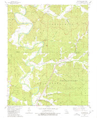
(8)- 1980 Map of Cascade
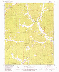 1980 Cascade1980 Print · USGSMadison and Wayne Counties are captured in the late seventies as rural life centered on the hollows and creek bottoms of the Ozarks. Genealogists and historians can trace family locations through numerous sites like Old Mt Pisgah Cem, Gravelton, and Zion Ch.
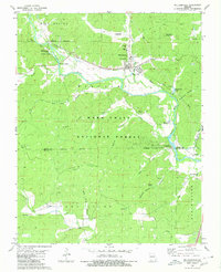
 - 1980 Map of Ellsinore
 1980 Ellsinore1980 Print · USGSIn the southeastern Ozarks during the late 1970s, this area centers on the small rail town of Ellsinore and the surrounding timbered hollows. Genealogists can trace several family burial sites including Hill Top Cem and Kearney Cem near the headwaters of Cane Creek.
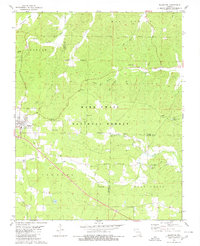
 - 1980 Map of Williamsville
 1980 Williamsville1980 Print · USGSThe Black River valley in the early eighties shows a landscape of deep Ozark forests and rail-fed settlements. You can trace old transit routes like the Old Military Road and local heritage at Holladay Cem and Keeners.
 - 1980 Map of Allbright
 1980 Allbright1980 Print · USGSSoutheast Missouri's river country comes to life in this survey from the late seventies, showing the rural communities along the Castor River. Genealogists can trace family names at Rhodes Cem, Millers Chapel, and the isolated Ivy Cem.
 - 1980 Map of Coldwater
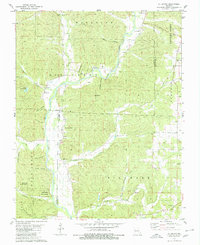
 1980 Coldwater1980 Print · USGSMadison and Wayne Counties in the 1980s show a landscape of deep hollows and family-held lands along the St Francis River. Researchers can trace old homesteads and rural landmarks like the Linville-Barrett Cem, Saco, and Oak Dale Ch.
 - 1983 Map of Poplar Bluff
 1983 Poplar Bluff1983 Print · USGSSoutheast Missouri in the early 1980s reveals a landscape defined by the Ozark foothills and the complex drainage systems of the Bootheel. Researchers can trace the rail corridors of the Missouri Pacific RR through Poplar Bluff or locate rural sites like Wilhelmina Church and Lone Hill Lookout.
 - 1986 Map of Piedmont
 1986 Piedmont1986 Print · USGSThe Missouri Ozarks are captured here in the mid-eighties as a region of dense state forests and critical river management. Genealogists and historians can trace family-named features and rural settlements like Piedmont, Lesterville, and the Yokum School.2 unique versions available
 - 1989 Map of Rolla
 1989 Rolla1989 Print · USGSThe Missouri Ozarks are captured in the late eighties as a landscape of national forests and historic mining towns. Researchers can trace the rail lines of the Missouri Pacific RR or locate landmarks like Taum Sauk Mtn and Elephant Rocks State Park.
End of results
Showing maps 1-8 of 8
Top cities of Wayne County
- Piedmont historical maps
- Greenville historical maps
- Williamsville historical maps
- Mill Spring historical maps
Frequently asked questions
- What are the different types of historical maps available for Wayne County?
- What is the oldest map of Wayne County?
- Where can I purchase historical maps of Wayne County for my home or office?
- Where can I download high-res historical maps of Wayne County?
- Are there historical topographic maps available for Wayne County?
- Is there historical aerial imagery available for Wayne County?
- Where are historical maps of Wayne County sourced from?