1940s Maps of Forkners Hill, Missouri
Explore 2 historic maps of Forkners Hill from the 1940s. These maps offer a rare glimpse into what life looked like during the 1940s — showing old roads, neighborhoods, homes, and landmarks that have changed or disappeared over time.
Whether you're researching your family's past, planning a metal detecting trip, or studying how Forkners Hill's landscape evolved across the 1940s, these high-resolution maps are a powerful tool for exploring the history of this region.
- Focus on a specific era: All maps on this page are from the 1940s, giving you a focused view of this time period.
- See what’s changed: Compare century-old streets, trails, and buildings to today's modern landscape using overlays and satellite layers.
- Research with precision: Use these maps for genealogy, historical research, land use analysis, or educational projects.
- View, download, or print: Maps are fully viewable online in high resolution, and can be downloaded or printed for your own records.
Start exploring Forkners Hill's history through authentic maps from the 1940s. This is your window into the past.
Forkners Hill, MO maps
(2)- 1946 Map of Niangua, 1966 Print
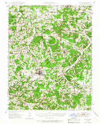 1946 Niangua1966 Print · USGSMid-century Webster County is shown here during a time when rural life centered on the St Louis-San Francisco rail line and local country schools. Genealogists can locate family landmarks such as Bumgardner Ford, Eighty Eight Sch, and Sparkle Brook Cem.
 - 1948 Map of Niangua
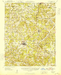 1948 Niangua1948 Print · USGSIn the late 1940s, Webster County was a landscape of small farming communities and river crossings. Trace the old rail line to Marshfield or find rural landmarks like Eighty Eight Sch, Mission Home Ch, and the crossings at Johnston Ford.2 unique versions available
End of results
Showing maps 1-2 of 2
Top cities near Forkners Hill
- Lebanon historical maps
- Marshfield historical maps
- Buffalo historical maps
- Strafford historical maps
- Fair Grove historical maps
- Conway historical maps
See more
Frequently asked questions
- What are the different types of historical maps available for Forkners Hill?
- What is the oldest map of Forkners Hill?
- Where can I purchase historical maps of Forkners Hill for my home or office?
- Where can I download high-res historical maps of Forkners Hill?
- Are there historical topographic maps available for Forkners Hill?
- Is there historical aerial imagery available for Forkners Hill?
- Where are historical maps of Forkners Hill sourced from?