1940s Maps of Wright County, Missouri
Explore 4 historic maps of Wright County from the 1940s. These maps offer a rare glimpse into what life looked like during the 1940s — showing old roads, neighborhoods, homes, and landmarks that have changed or disappeared over time.
Whether you're researching your family's past, planning a metal detecting trip, or studying how Wright County's landscape evolved across the 1940s, these high-resolution maps are a powerful tool for exploring the history of this region.
- Focus on a specific era: All maps on this page are from the 1940s, giving you a focused view of this time period.
- See what’s changed: Compare century-old streets, trails, and buildings to today's modern landscape using overlays and satellite layers.
- Research with precision: Use these maps for genealogy, historical research, land use analysis, or educational projects.
- View, download, or print: Maps are fully viewable online in high resolution, and can be downloaded or printed for your own records.
Start exploring Wright County's history through authentic maps from the 1940s. This is your window into the past.
Wright County, MO maps
(4)- 1941 Map of Manes, 1965 Print
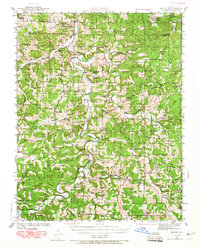 1941 Manes1965 Print · USGSThe northern Ozarks come to life in this mid-century survey of the Gasconade River valley and the surrounding hills of Laclede and Wright counties. Genealogists can trace family footprints through numerous rural landmarks like Grimes Mill, McBride Cem, and the village of Manes.2 unique versions available
 - 1941 Map of Bado, 1974 Print
 1941 Bado1974 Print · USGSTexas County, Missouri, is documented here in the early 1940s, showing a landscape of small upland farms and forest communities. Genealogists can trace family roots through numerous sites like Old Union Cem, Bucyrus, and Pleasant Ridge Sch.
 - 1943 Map of Manes
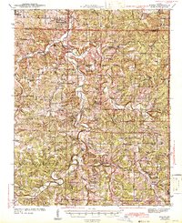 1943 Manes1943 Print · USGSWright and Laclede counties are shown here in the 1940s as a landscape of river-bottom farms and rural school districts. Researchers can trace family ties through dozens of local landmarks like Latham Mill, Competition, and Indian Grove Sch.3 unique versions available
 - 1943 Map of Bado
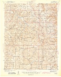 1943 Bado1943 Print · USGSThe Missouri Ozarks are captured here in the early 1940s, showing a landscape defined by the Mark Twain National Forest and rural river valleys. Genealogists can trace family roots through numerous landmarks like Lynch Cem, Ragsdale Sch, and the Barium Mine.3 unique versions available
End of results
Showing maps 1-4 of 4
Top cities of Wright County
Frequently asked questions
- What are the different types of historical maps available for Wright County?
- What is the oldest map of Wright County?
- Where can I purchase historical maps of Wright County for my home or office?
- Where can I download high-res historical maps of Wright County?
- Are there historical topographic maps available for Wright County?
- Is there historical aerial imagery available for Wright County?
- Where are historical maps of Wright County sourced from?