1980s Maps of Wright County, Missouri
Explore 7 historic maps of Wright County from the 1980s. These maps offer a rare glimpse into what life looked like during the 1980s — showing old roads, neighborhoods, homes, and landmarks that have changed or disappeared over time.
Whether you're researching your family's past, planning a metal detecting trip, or studying how Wright County's landscape evolved across the 1980s, these high-resolution maps are a powerful tool for exploring the history of this region.
- Focus on a specific era: All maps on this page are from the 1980s, giving you a focused view of this time period.
- See what’s changed: Compare century-old streets, trails, and buildings to today's modern landscape using overlays and satellite layers.
- Research with precision: Use these maps for genealogy, historical research, land use analysis, or educational projects.
- View, download, or print: Maps are fully viewable online in high resolution, and can be downloaded or printed for your own records.
Start exploring Wright County's history through authentic maps from the 1980s. This is your window into the past.
Wright County, MO maps
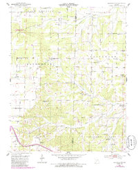
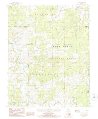
(7)- 1983 Map of Mountain Grove
 1983 Mountain Grove1983 Print · USGSWright and Webster counties in the early 1980s show a traditional Ozark landscape of ridge-running railroads and river headwaters. You can trace the Burlington Northern Railroad through towns like Mansfield or find rural landmarks like Vance Cem and Mt Zion Church.
 - 1985 Map of Mansfield NW
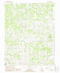
 1985 Mansfield NW1985 Print · USGSThe Ozark plateau north of Mansfield is captured here in the mid-1980s, documenting a network of family cemeteries and remote river valleys. You can trace the shift from active settlements to memory at Mt Olive Sch (Abandoned) and locate old family plots at Newton Cem or Peters Cem.
 - 1987 Map of Fuson
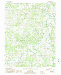 1987 Fuson1987 Print · USGSWright County in the late 1980s is defined by the winding Gasconade River and the rural community of Fuson. Genealogists and local historians can locate early industrial sites like Grimes Mill and Latham Mill or find remote Cem locations along the hollows.
 - 1987 Map of Huggins
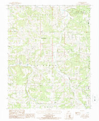
 1987 Huggins1987 Print · USGSThe Missouri Ozarks are captured here in the late eighties, featuring a landscape of deep hollows and rural crossroads. Researchers can trace family history through sites in Huggins, Bendavis, and Upton, or locate landmarks like the Pairlee Freeman Barnes State Wildlife Area.
 - 1987 Map of Dawson
 1987 Dawson1987 Print · USGSWright County, Missouri, is captured here in the late eighties as a landscape of remote townships and deep Ozark hollows. Genealogists and local historians can trace the vicinity of Dawson, Graff, and Rayborn along the winding banks of Dove Creek and Beaver Creek.
 - 1987 Map of Competition
 1987 Competition1987 Print · USGSWright and Laclede Counties during the 1980s show a landscape of deep hollows and river bends along the Gasconade River. Researchers can locate old settlements like Competition, Jerktail, and St George nestled among the hills and forest land.
 - 1987 Map of Manes
 1987 Manes1987 Print · USGSThe Manes and Lynchburg area of Wright County comes to life in the late 1980s, showcasing the interplay of the Ozark woodlands and remote farmsteads. Trace old property lines and rural centers like Mingsville, Embree, and the local Cem.
End of results
Showing maps 1-7 of 7
Top cities of Wright County
Frequently asked questions
- What are the different types of historical maps available for Wright County?
- What is the oldest map of Wright County?
- Where can I purchase historical maps of Wright County for my home or office?
- Where can I download high-res historical maps of Wright County?
- Are there historical topographic maps available for Wright County?
- Is there historical aerial imagery available for Wright County?
- Where are historical maps of Wright County sourced from?