1970s Maps of Beaverhead County, Montana
Explore 18 historic maps of Beaverhead County from the 1970s. These maps offer a rare glimpse into what life looked like during the 1970s — showing old roads, neighborhoods, homes, and landmarks that have changed or disappeared over time.
Whether you're researching your family's past, planning a metal detecting trip, or studying how Beaverhead County's landscape evolved across the 1970s, these high-resolution maps are a powerful tool for exploring the history of this region.
- Focus on a specific era: All maps on this page are from the 1970s, giving you a focused view of this time period.
- See what’s changed: Compare century-old streets, trails, and buildings to today's modern landscape using overlays and satellite layers.
- Research with precision: Use these maps for genealogy, historical research, land use analysis, or educational projects.
- View, download, or print: Maps are fully viewable online in high resolution, and can be downloaded or printed for your own records.
Start exploring Beaverhead County's history through authentic maps from the 1970s. This is your window into the past.
Beaverhead County, MT maps
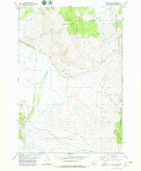
(18)- 1974 Map of Bender Point, 1977 Print
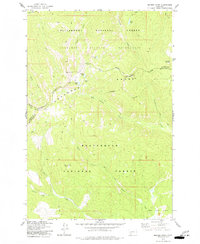 1974 Bender Point1977 Print · USGSThe high country of the Beaverhead and Ravalli county line is documented here in the mid-1970s. Trace the path of the Continental Divide and find remote alpine features like Carmine Lake and Bender Point.2 unique versions available
 - 1975 Map of Butte South
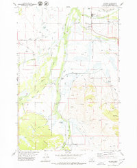
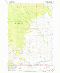
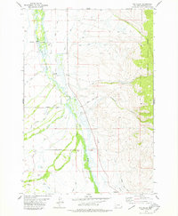
 1975 Butte South1975 Print · USGSIn the mid-1970s, the mountainous terrain south of Butte was a hub of mining and rail activity. You can trace the Burlington Northern line through historic settlements like Melrose, Twin Bridges, and Whitehall, or locate family-named mines including Watseca Mine and Hecla Mines.
 - 1976 Map of Monument Hill, 1980 Print
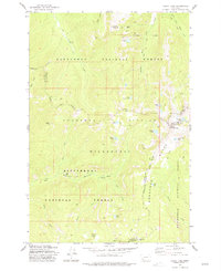
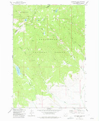
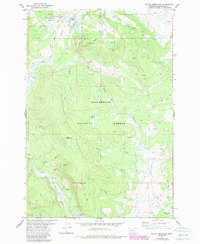
 1976 Monument Hill1980 Print · USGSThe high Beaverhead County range in the mid-1970s is shown here as a landscape of isolated homesteads and high-elevation trails. Researchers can trace historic land use through sites like Wheat Ranch, the Radio Facility, and named landmarks such as Monument Hill.
 - 1977 Map of Sula
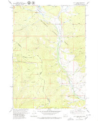
 1977 Sula1977 Print · USGSThe Bitterroot Valley south of Hamilton comes into focus in the 1970s, showcasing the high-country transition from Ross Hole to the Continental Divide. Researchers can trace family sites near Sula, locate the Sula Cem, and follow the Bitterroot River headwaters.2 unique versions available
 - 1977 Map of Kelly Lake
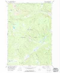
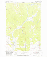
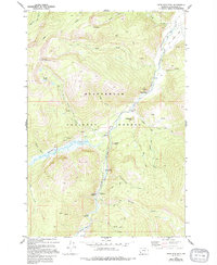
 1977 Kelly Lake1977 Print · USGSThe Anaconda Range and the surrounding national forests are captured here in the 1970s, showcasing a high-altitude landscape where four Montana counties meet. Outdoor researchers and historians can trace high-country paths like the Alpine Trail to remote landmarks such as the Senate Mine, Pintlar Peak, and Star Falls.3 unique versions available
 - 1977 Map of Mussigbrod Lake
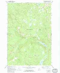
 1977 Mussigbrod Lake1977 Print · USGSBeaverhead County alpine wilderness is documented here in the late seventies, showing the meeting of national forests at the Continental Divide. Trace the remote pack trails connecting Mussigbrod Lake, Mystic Lake, and the Forest Service Station.2 unique versions available
 - 1977 Map of Schultz Saddle, 1978 Print
 1977 Schultz Saddle1978 Print · USGSThe high Montana wilderness along the Continental Divide is mapped here in the late seventies. You can trace early backcountry access routes via Pack Trail and Jeep Trail networks near Schultz Saddle and Tolan Ridge.
 - 1978 Map of Odell Lake
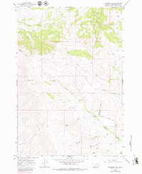
 1978 Odell Lake1978 Print · USGSBeaverhead County is shown in the late 1970s as a landscape of high-country grazing and mineral exploration. Researchers can trace historical ranching at Anderson Meadows Cow Camp or locate alpine mineral sites like the Mines near Schweinegar Lake.
 - 1978 Map of Maurice Mountain
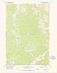 1978 Maurice Mountain1978 Print · USGSIn the late 1970s, this area of the Beaverhead National Forest maintained its character as a rugged landscape of old rail grades and high-country basins. You can trace the Old Wise River Railroad Grade along the Wise River or locate the remote Maurice Cemetery.
 - 1978 Map of Jackson, 1979 Print
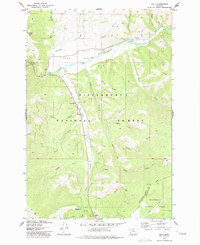
 1978 Jackson1979 Print · USGSBeaverhead County ranching and recreation are well established in this late seventies survey of the Big Hole Valley. Researchers can trace family history through Popularis Cemetery or locate local landmarks like Jardine Hot Spring, the Ski Hill, and the Englejard settlement.2 unique versions available
 - 1978 Map of Butch Hill, 1979 Print
 1978 Butch Hill1979 Print · USGSBeaverhead County ranching and water rights are well-documented in this late 1970s survey of the high-country landscape. Genealogists and historians can locate specific ranch sites like Hairpin Ranch and trace the complex irrigation network of the Main Jackson Ditch and Wengers Ditch.
 - 1978 Map of Coyote Creek, 1979 Print
 1978 Coyote Creek1979 Print · USGSBeaverhead County in the late seventies is captured here as a landscape of high-country mining and forest management. Trace the historic Horse Prairie Guard Station and the industrial remains of the Monument Mine or the distinctive Bloody Dick Ditch.
 - 1978 Map of Kitty Creek, 1979 Print
 1978 Kitty Creek1979 Print · USGSThe high Bitterroot Range comes into focus during the late 1970s as it straddles the Idaho-Montana border. Researchers can trace remote alpine infrastructure like the Bloody Dick Guard Sta, the Landing Strip, and Hughes Cow Camp.2 unique versions available
 - 1978 Map of Jackson Hill, 1979 Print
 1978 Jackson Hill1979 Print · USGSBeaverhead County ranching and mining land are captured here in the late seventies. Local historians can trace the high-country routes to Clemow Cow Camp, the workings at Carney Mine, and old water rights along the Upper Gloss Ditch.
 - 1978 Map of Fox Gulch, 1979 Print
 1978 Fox Gulch1979 Print · USGSBeaverhead County ranching life is well-documented in the late seventies as family operations spread across the Big Hole River valley. Genealogists and local historians can trace legacy properties like 40 Bar Ranch and Willow Ranch, or locate the Popularis Cem.2 unique versions available
 - 1978 Map of Selway Mountain, 1989 Print
 1978 Selway Mountain1989 Print · USGSBeaverhead County’s high timber and mining lands are captured here in the late seventies. Researchers can trace the Saginaw Mine and isolated outposts like Jackson Cow Camp or the seasonal Skinner Meadows.
 - 1978 Map of Stine Mountain, 1994 Print
 1978 Stine Mountain1994 Print · USGSBeaverhead National Forest during the late seventies shows a landscape of mountain peaks and river valleys. Genealogists and historians can trace an Old Railroad Grade along the Wise River or locate remote sites like Flying Cloud Ranch.
 - 1978 Map of Shaw Mountain, 1994 Print
 1978 Shaw Mountain1994 Print · USGSHigh in the Montana backcountry during the late twentieth century, this area shows a landscape of mountain peaks and pack trails. Researchers can locate remote landmarks like Kelley Cabin, Bible Camp Park, and the high waters of Stone Lakes.
End of results
Showing maps 1-18 of 18
Top cities of Beaverhead County
Frequently asked questions
- What are the different types of historical maps available for Beaverhead County?
- What is the oldest map of Beaverhead County?
- Where can I purchase historical maps of Beaverhead County for my home or office?
- Where can I download high-res historical maps of Beaverhead County?
- Are there historical topographic maps available for Beaverhead County?
- Is there historical aerial imagery available for Beaverhead County?
- Where are historical maps of Beaverhead County sourced from?