1900-1909 Maps of Blaine County, Montana
Explore 6 historic maps of Blaine County from 1900-1909. These maps offer a rare glimpse into what life looked like during the 1900s — showing old roads, neighborhoods, homes, and landmarks that have changed or disappeared over time.
Whether you're researching your family's past, planning a metal detecting trip, or studying how Blaine County's landscape evolved across the 1900s, these high-resolution maps are a powerful tool for exploring the history of this region.
- Focus on a specific era: All maps on this page are from the 1900s, giving you a focused view of this time period.
- See what’s changed: Compare century-old streets, trails, and buildings to today's modern landscape using overlays and satellite layers.
- Research with precision: Use these maps for genealogy, historical research, land use analysis, or educational projects.
- View, download, or print: Maps are fully viewable online in high resolution, and can be downloaded or printed for your own records.
Start exploring Blaine County's history through authentic maps from the 1900s. This is your window into the past.
Blaine County, MT maps
(6)- 1903 Map of Wayne Creek, 1958 Print
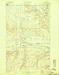
 1903 Wayne Creek1958 Print · USGSBlaine County was an open ranching landscape at the turn of the century, defined by the northern plains and the river valley corridor. Trace the early Great Plains rail economy at Montauk along the Great Northern RR and locate pioneer outposts like Nickols Ranch.
 - 1904 Map of Yantic
 1904 Yantic1904 Print · USGSNorthern Montana ranching life is frozen in time on this 1904 survey of the Milk River valley. Researchers can trace early homesteads like Potter's Ranch and Empire Ranch or follow the route of the Great Northern R. R. through Yantic.2 unique versions available
 - 1904 Map of Chinook
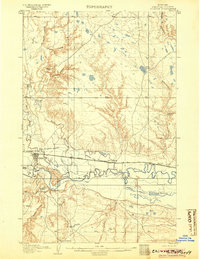 1904 Chinook1904 Print · USGSLife in the Milk River Valley at the dawn of the century revolved around the rail lines and new irrigation canals. Researchers can trace early ranch holdings like Nelson's Ranch and Ronne's Ranch or locate the site of Kerrs Coalmine.2 unique versions available
 - 1904 Map of Havre
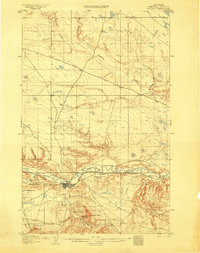 1904 Havre1904 Print · USGSHavre and the Milk River valley are captured in this early century survey as the region transitioned from a frontier military outpost to a railroad-driven settlement. Researchers can trace the original locations of numerous family homesteads like Conley's Ranch and Mc Grew's Ranch, alongside the sprawling Fort Assinniboine Mil. Res..2 unique versions available
 - 1905 Map of Wayne Creek
 1905 Wayne Creek1905 Print · USGSEarly ranching and rail expansion characterize this northern Montana landscape in the first decade of the new century. Researchers can trace historic homesteads like Reddenbacks and Nickols Ranch along the route of the Great Northern R R.
 - 1905 Map of Harlem
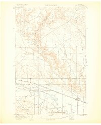 1905 Harlem1905 Print · USGSThe Milk River valley at the turn of the century shows a landscape transitioning from open range to irrigated agriculture and rail-side settlements. Researchers can locate early outposts like Sorterstorm's Ranch and follow the route of the Great Northern R R past Harlem and Madras.2 unique versions available
End of results
Showing maps 1-6 of 6
Top cities of Blaine County
Frequently asked questions
- What are the different types of historical maps available for Blaine County?
- What is the oldest map of Blaine County?
- Where can I purchase historical maps of Blaine County for my home or office?
- Where can I download high-res historical maps of Blaine County?
- Are there historical topographic maps available for Blaine County?
- Is there historical aerial imagery available for Blaine County?
- Where are historical maps of Blaine County sourced from?