1970s Maps of Pondera County, Montana
Explore 3 historic maps of Pondera County from the 1970s. These maps offer a rare glimpse into what life looked like during the 1970s — showing old roads, neighborhoods, homes, and landmarks that have changed or disappeared over time.
Whether you're researching your family's past, planning a metal detecting trip, or studying how Pondera County's landscape evolved across the 1970s, these high-resolution maps are a powerful tool for exploring the history of this region.
- Focus on a specific era: All maps on this page are from the 1970s, giving you a focused view of this time period.
- See what’s changed: Compare century-old streets, trails, and buildings to today's modern landscape using overlays and satellite layers.
- Research with precision: Use these maps for genealogy, historical research, land use analysis, or educational projects.
- View, download, or print: Maps are fully viewable online in high resolution, and can be downloaded or printed for your own records.
Start exploring Pondera County's history through authentic maps from the 1970s. This is your window into the past.
Pondera County, MT maps
(3)- 1970 Map of Sollid School, 1973 Print
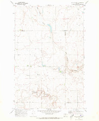 1970 Sollid School1973 Print · USGSThe Montana plains north of Conrad are captured here in the early seventies, showing a landscape defined by deep coulees and rural section lines. Researchers can locate the Sollid School, Golden West Ch, and Golden West Cem while tracing the winding Pondera Coulee.
 - 1970 Map of Faris School, 1973 Print
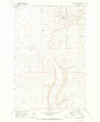 1970 Faris School1973 Print · USGSNorthern Montana prairie life in the early seventies centers on remote community hubs along the Pondera and Chouteau county line. Local historians can trace the foundations of the Faris School, the East Community Center, and the essential East Community Well.
 - 1976 Map of Great Falls North, 1990 Print
 1976 Great Falls North1990 Print · USGSNorth of the Missouri River in the mid-seventies, this survey shows a region defined by extensive irrigation projects and the growing footprint of Great Falls. Researchers can trace the Burlington Northern rail lines through Dutton or locate the sprawling Benton Lake National Wildlife Refuge.
End of results
Showing maps 1-3 of 3
Top cities of Pondera County
Frequently asked questions
- What are the different types of historical maps available for Pondera County?
- What is the oldest map of Pondera County?
- Where can I purchase historical maps of Pondera County for my home or office?
- Where can I download high-res historical maps of Pondera County?
- Are there historical topographic maps available for Pondera County?
- Is there historical aerial imagery available for Pondera County?
- Where are historical maps of Pondera County sourced from?