1950s Maps of Pondera County, Montana
Explore 8 historic maps of Pondera County from the 1950s. These maps offer a rare glimpse into what life looked like during the 1950s — showing old roads, neighborhoods, homes, and landmarks that have changed or disappeared over time.
Whether you're researching your family's past, planning a metal detecting trip, or studying how Pondera County's landscape evolved across the 1950s, these high-resolution maps are a powerful tool for exploring the history of this region.
- Focus on a specific era: All maps on this page are from the 1950s, giving you a focused view of this time period.
- See what’s changed: Compare century-old streets, trails, and buildings to today's modern landscape using overlays and satellite layers.
- Research with precision: Use these maps for genealogy, historical research, land use analysis, or educational projects.
- View, download, or print: Maps are fully viewable online in high resolution, and can be downloaded or printed for your own records.
Start exploring Pondera County's history through authentic maps from the 1950s. This is your window into the past.
Pondera County, MT maps
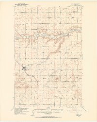
(8)- 1950 Map of Timber Coulee
 1950 Timber Coulee1950 Print · USGSMontana's high prairie and river breaks are documented here in the mid-1940s, showing a landscape defined by the winding Teton River. Genealogists and local historians can trace the locations of the Knee Church, the Jensen Elevator, and early rural schools like Promised Land School.
 - 1950 Map of Dutton, 1952 Print
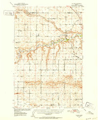
 1950 Dutton1952 Print · USGSDutton and the surrounding Teton County plains are shown in the early 1950s as a thriving rail-side agricultural community. Genealogists can trace a network of rural schoolhouses like Doheney School and Pleasant School, alongside the Great Northern railroad line.3 unique versions available
 - 1950 Map of Collins, 1952 Print
 1950 Collins1952 Print · USGSTeton County and Pondera County meet along the meanders of the Teton River at the height of the post-war ranching and rail era. Researchers can trace the rural school network including South Liberty Sch, or locate family landmarks like Beck Cem and the grain hub at Zim Elevator.2 unique versions available
 - 1954 Map of Great Falls
 1954 Great Falls1954 Print · USGSThe Missouri River valley in the mid-1950s is shown at a time of significant industrial and military growth. Genealogists and historians can locate early schools and rail stops like Tiger Butte Community Center, Fort Benton, and the Anaconda Wire Plant.4 unique versions available
 - 1954 Map of Shelby, 1967 Print
 1954 Shelby1967 Print · USGSNorthern Montana's Hi-Line is captured in the mid-fifties, showing a landscape shaped by the Great Northern rail and early oil development. Trace family roots in Shelby and Conrad, or locate rural landmarks like Goose Bill Butte and the Rocky Boys Indian Reservation.3 unique versions available
 - 1957 Map of Great Falls
 1957 Great Falls1957 Print · USGSMontana's central plains and mountain foothills are captured here in the mid-fifties, showing the hub of Great Falls and the surrounding grain-shipping towns. Genealogists can trace family roots through the rail sidings of the Great Northern and small rural communities like Sand Coulee or Fort Benton.
 - 1958 Map of Shelby
 1958 Shelby1958 Print · USGSNorthern Montana’s high plains and the Sweetgrass Hills come to life in the late fifties as the Tiber Dam begins to reshape the Marias River valley. Genealogists and historians can trace rail-town lineages along the Great Northern line and locate sites like the Hull Coal Mine or Sweet Grass.
 - 1958 Map of Crescent Cliff, 1960 Print
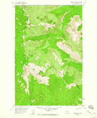 1958 Crescent Cliff1960 Print · USGSThe Montana wilderness at the crest of the Rockies comes alive in the late fifties, where the Continental Divide splits the national forests. Follow primitive backcountry routes like the Kip Pack Trail and Calbick Trail past landmarks such as Bruin Peaks and Goat Mountain.3 unique versions available
End of results
Showing maps 1-8 of 8
Top cities of Pondera County
Frequently asked questions
- What are the different types of historical maps available for Pondera County?
- What is the oldest map of Pondera County?
- Where can I purchase historical maps of Pondera County for my home or office?
- Where can I download high-res historical maps of Pondera County?
- Are there historical topographic maps available for Pondera County?
- Is there historical aerial imagery available for Pondera County?
- Where are historical maps of Pondera County sourced from?