1980s Maps of Pondera County, Montana
Explore 22 historic maps of Pondera County from the 1980s. These maps offer a rare glimpse into what life looked like during the 1980s — showing old roads, neighborhoods, homes, and landmarks that have changed or disappeared over time.
Whether you're researching your family's past, planning a metal detecting trip, or studying how Pondera County's landscape evolved across the 1980s, these high-resolution maps are a powerful tool for exploring the history of this region.
- Focus on a specific era: All maps on this page are from the 1980s, giving you a focused view of this time period.
- See what’s changed: Compare century-old streets, trails, and buildings to today's modern landscape using overlays and satellite layers.
- Research with precision: Use these maps for genealogy, historical research, land use analysis, or educational projects.
- View, download, or print: Maps are fully viewable online in high resolution, and can be downloaded or printed for your own records.
Start exploring Pondera County's history through authentic maps from the 1980s. This is your window into the past.
Pondera County, MT maps
(22)- 1981 Map of Hungry Horse Reservoir, 1982 Print
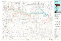
 1981 Hungry Horse Reservoir1982 Print · USGSThe Flathead region in the early eighties shows a wilderness managed through rail and reservoir. Genealogists and historians can trace rail-stop settlements like Nyack, Essex, and Summit along the Burlington Northern line and the John F Stevens Canyon.
 - 1984 Map of Conrad
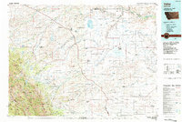
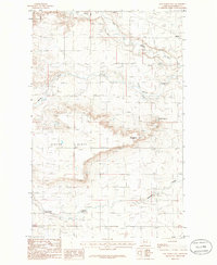
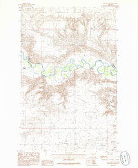
 1984 Conrad1984 Print · USGSNorth-central Montana's high plains and river valleys come to life in this mid-eighties record of Pondera and Toole counties. Genealogists and historians can trace rail-stop towns along the Burlington Northern or locate rural landmarks like Favot and Alkali Springs.
 - 1984 Map of Valier
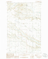
 1984 Valier1984 Print · USGSNorthwestern Montana in the mid-1980s reveals a unique landscape of Hutterite agricultural colonies and high mountain wilderness. Genealogists and historians can trace the irrigation networks and rail stops from Valier to Birch Creek Colony and the Kellogg Mine.
 - 1985 Map of Agawam North, 1986 Print
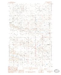
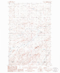
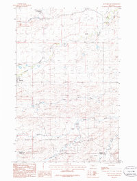
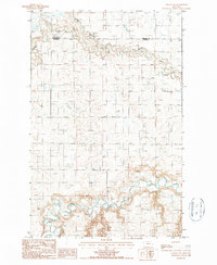
 1985 Agawam North1986 Print · USGSThe high plains of the Teton and Pondera county line are captured here in the mid-1980s during a period of active energy and water development. Researchers can trace the sprawling Oil Field north of Agawam and the winding path of the Bynum Canal.
 - 1985 Map of Gallup City, 1986 Print
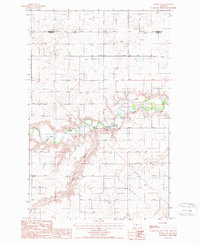
 1985 Gallup City1986 Print · USGSGallup City and the oil fields of Teton and Pondera counties are captured here in the mid-eighties as a landscape of energy production and prairie ranching. Researchers can trace land features like Porter Bench or locate the local Cem and Aldrich Spring.
 - 1985 Map of Valier West, 1986 Print
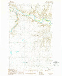
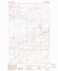
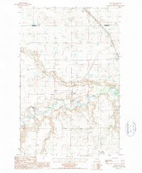
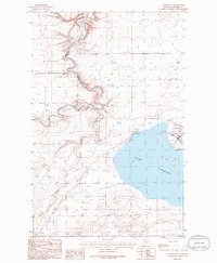 1985 Valier West1986 Print · USGSPondera County at the mid-eighties shows a landscape defined by the intersection of the Blackfeet Indian Reservation and large-scale irrigation projects. Researchers can trace the water network from Lake Frances through the A N 2 Canal to the town of Valier.
 - 1985 Map of Flag Butte, 1986 Print
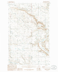
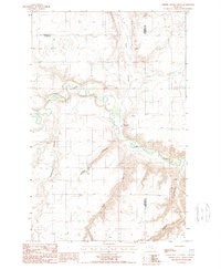
 1985 Flag Butte1986 Print · USGSThe Blackfeet Indian Reservation in the mid-1980s is documented here as a landscape of irrigation and prairie. Researchers can trace the complex water systems of the Badger Fisher Main Canal and Alkali Lake near the landmark of Flag Butte.
 - 1985 Map of Sam George Hill, 1986 Print
 1985 Sam George Hill1986 Print · USGSPondera County during the mid-1980s shows a landscape of high plateaus and carved coulees at the height of regional resource management. Genealogists and historians can trace the small community of Manson and find landmarks like Sam George Hill and the active Oil Field.
 - 1985 Map of Lone Man Coulee West, 1986 Print
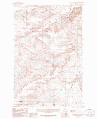
 1985 Lone Man Coulee West1986 Print · USGSThe confluence of the Marias River forks in Montana was a vital landscape for water management and communal living in the mid-1980s. Researchers can trace the layout of the New Miami Colony and locate physical landmarks like Black Buttes and Frances Heights.
 - 1985 Map of Abbott Lake, 1986 Print
 1985 Abbott Lake1986 Print · USGSMontana's northern plains are captured here in the mid-1980s at the confluence of the Marias River and Two Medicine River. Researchers can trace irrigation networks and water features including Bullhead Springs and Abbott Lake.
 - 1985 Map of Rock City, 1986 Print
 1985 Rock City1986 Print · USGSThe Blackfeet Indian Reservation in the mid-eighties shows a landscape of high-plains water management and energy development. Genealogists can trace family-named sites like Shields Crossing and explore the industrial footprint of the northern Oil Field sites.
 - 1985 Map of Dupuyer East, 1986 Print
 1985 Dupuyer East1986 Print · USGSThe Pondera and Teton county line area in the mid-1980s shows a landscape of wide-open ranch land and complex river forks. Trace the branching of the Dry Fork Marias River or locate local landmarks like Birch Creek Colony and Crocker Springs.
 - 1985 Map of Cactus Flat, 1986 Print
 1985 Cactus Flat1986 Print · USGSThe Marias River border country in the mid-eighties was a landscape of high flats and deep coulees. Trace the water-driven development of the region through the Canal, the settlement at Willow Rounds, and the expansive Cactus Flat.
 - 1985 Map of Kuka Crossing, 1986 Print
 1985 Kuka Crossing1986 Print · USGSPondera County and reservation lands meet along the winding Birch Creek in the mid-1980s. Local historians and genealogists can trace the isolated Kingsbury Colony and key stream crossings like Kuka Crossing and Pierce Crossing as they appeared forty years ago.
 - 1985 Map of Belgian Hill, 1986 Print
 1985 Belgian Hill1986 Print · USGSMid-1980s Pondera County was a landscape of high plains irrigation and coulee-cut terrain. Researchers can trace the water-delivery systems of the Ringwald Canal and C Canal or locate local landmarks like Belgian Hill and a rural Cem.
 - 1985 Map of Valier East, 1986 Print
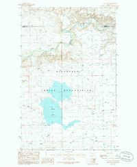
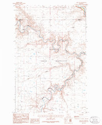
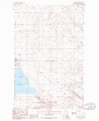 1985 Valier East1986 Print · USGSThe Pondera County plains come to life in the mid-eighties as the town of Valier stands beside the broad waters of Lake Frances. Researchers can trace the region's infrastructure through features like the A N 2 Canal, the settlement of Williams, and the Valier Municipal Airport.
 - 1985 Map of Lone Man Coulee East, 1986 Print
 1985 Lone Man Coulee East1986 Print · USGSPondera and Teton County lands in the mid-1980s are defined by the winding course of the Marias River and its deep coulees. Researchers can trace land features like Castle Rock and Benton Bench alongside industrial Gravel Pits.
 - 1987 Map of Collins NW
 1987 Collins NW1987 Print · USGSThe Teton River valley and the southern edge of the High Plains are captured here in the late 1980s. Researchers can trace the winding course of the Teton River and find localized geographic features like Alkali Flat and Kropp Coulee.
 - 1987 Map of Dutton NE
 1987 Dutton NE1987 Print · USGSThe Teton River valley near the Pondera county line is captured in the late eighties as a landscape of energy and irrigation. Genealogists and researchers can trace the river's infrastructure through Kerr Bridge, an active Oil Field, and the Owp Trans Line.
 - 1987 Map of Collins
 1987 Collins1987 Print · USGSThe Teton County high plains come into focus in the late 1980s, showcasing a landscape defined by prairie waterways and fading rail lines. Researchers can trace the legacy of local transport via the Old Railroad and Old RR Grade near Collins and Acme.
 - 1987 Map of Dutton NW
 1987 Dutton NW1987 Print · USGSTeton County and Pondera County are shown here in the late eighties as the high plains landscape adapted to changing infrastructure. Researchers can trace the path of the Old RR Grade and locate features like Hunt Coulee and the Teton River.
 - 1987 Map of Timber Coulee North
 1987 Timber Coulee North1987 Print · USGSThe Teton River valley near the Pondera and Chouteau county lines was a center for regional utility and transport during the late twentieth century. Genealogists and researchers can trace local landmarks like Nipple and industrial sites such as the Gas Compressor Station and Spencer Coulee.
End of results
Showing maps 1-22 of 22
Top cities of Pondera County
Frequently asked questions
- What are the different types of historical maps available for Pondera County?
- What is the oldest map of Pondera County?
- Where can I purchase historical maps of Pondera County for my home or office?
- Where can I download high-res historical maps of Pondera County?
- Are there historical topographic maps available for Pondera County?
- Is there historical aerial imagery available for Pondera County?
- Where are historical maps of Pondera County sourced from?