1900s (20th Century) Maps of Ravalli County, Montana
Explore 174 historic maps of Ravalli County from the 1900s (20th Century). These maps offer a rare glimpse into what life looked like during the 1900s — showing old roads, neighborhoods, homes, and landmarks that have changed or disappeared over time.
Whether you're researching your family's past, planning a metal detecting trip, or studying how Ravalli County's landscape evolved across the 1900s, these high-resolution maps are a powerful tool for exploring the history of this region.
- Focus on a specific era: All maps on this page are from the 1900s, giving you a focused view of this time period.
- See what’s changed: Compare century-old streets, trails, and buildings to today's modern landscape using overlays and satellite layers.
- Research with precision: Use these maps for genealogy, historical research, land use analysis, or educational projects.
- View, download, or print: Maps are fully viewable online in high resolution, and can be downloaded or printed for your own records.
Start exploring Ravalli County's history through authentic maps from the 1900s. This is your window into the past.
Ravalli County, MT maps
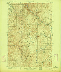
(174)- 1901 Map of Hamilton
 1901 Hamilton1901 Print · USGSThe Bitterroot Valley in the late nineteenth century is a landscape of emerging rail towns and sophisticated irrigation. Trace the development of early Hamilton and Victor alongside the Northern Pacific Railway and historic canals like Republican Ditch.6 unique versions available
 - 1903 Map of Bonner
 1903 Bonner1903 Print · USGSMissoula and the surrounding river canyons come to life in this turn-of-the-century survey during the height of early rail expansion. Trace the original path of the Northern Pacific through mountain passes and locate early settlements like Bonner, Potomac, and Clinton.4 unique versions available
 - 1909 Map of Sapphire
 1909 Sapphire1909 Print · USGSThe high Montana wilderness of the Sapphire and Bitterroot ranges is captured in the early 1900s, showing the border between Granite and Ravalli counties. Genealogists and researchers can trace family-named landmarks like Dominic Butte or explore remote basins like Frogpond Basin and Moose Meadows.3 unique versions available
 - 1911 Map of Lolo, 1954 Print
 1911 Lolo1954 Print · USGSThe Bitterroot wilderness at the dawn of the Forest Service era is documented here through its early camps and trail networks. Researchers can locate remote outposts like Moose City, the Clearwater Gold and Copper Company, and the historic Indian Post Office landmark.
 - 1912 Map of Missoula
 1912 Missoula1912 Print · USGSWestern Montana at the end of the frontier era shows a landscape of growing rail hubs and remote mountain outposts. Researchers can trace early river crossings like Alberts Ferry, the grounds of Ft Missoula, and vanished schools such as Big Flat School.4 unique versions available
 - 1913 Map of Lolo
 1913 Lolo1913 Print · USGSThe Bitterroot wilderness of the early 1900s is documented here through a web of mining camps, ranger stations, and high mountain passes. Genealogists and researchers can locate remote sites like Moose City, Williams Ranch, and the Clearwater Gold and Copper Company.2 unique versions available
 - 1947 Map of Butte, 1949 Print
 1947 Butte1949 Print · USGSWestern Montana at the peak of its rail-and-river era shows the vital connections between the mining and industrial centers of Butte and Helena. Researchers can trace the three major railroad lines serving mountain settlements like Garrison, Philipsburg, and Warm Springs.2 unique versions available
 - 1955 Map of Dillon, 1978 Print
 1955 Dillon1978 Print · USGSSouthwest Montana at the dawn of the interstate era reveals a landscape of high-mountain ranching and historic mining camps. Trace the routes of the Union Pacific through Dillon and Armstead, or locate early settlements like Bannack and Wisdom.2 unique versions available
 - 1956 Map of Elk City, 1963 Print
 1956 Elk City1963 Print · USGSThe Idaho backcountry in the mid-fifties remains a landscape of isolated mining camps and remote forest outposts. Researchers can trace historical mining operations at Stibnite Mine and Blackbird Mine or locate riverside landmarks like Mackay Bar and Campbell's Ferry.3 unique versions available
 - 1956 Map of Hamilton, 1970 Print
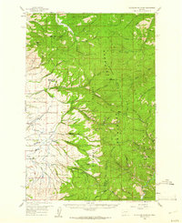
 1956 Hamilton1970 Print · USGSThe Bitterroot Valley and surrounding high country are captured here during the mid-fifties, showing the region's transition into a modern forest-and-rail hub. Genealogists and historians can trace family-named sites and early infrastructure from Fort Missoula to towns like Stevensville and Darby along the Northern Pacific line.2 unique versions available
 - 1957 Map of Dillon
 1957 Dillon1957 Print · USGSSouthwest Montana and Idaho in the mid-fifties reveal a high-country landscape of mountain ranges and ranching valleys. Genealogists can trace family holdings and rail stops along the Union Pacific Railroad, from Dillon to historic Virginia City and Twin Bridges.
 - 1958 Map of Butte
 1958 Butte1958 Print · USGSWestern Montana's mining and rail corridors are captured in the late fifties, from the urban bustle of the Copper King cities to high mountain passes. Researchers can trace the path of the Milwaukee St Paul and Pacific through Deer Lodge and locate remote outposts like Potomac Post Office.5 unique versions available
 - 1958 Map of Dillon
 1958 Dillon1958 Print · USGSSouthwestern Montana during the late fifties reveals a high-country landscape defined by the Continental Divide and a legacy of mountain mining. Genealogists and historians can trace rail lines like the Union Pacific or locate early industrial sites including the Hecla Mine and Ermont Mine.
 - 1959 Map of Hamilton
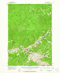
 1959 Hamilton1959 Print · USGSThe Bitterroot Valley and surrounding wilderness are captured in the late fifties, showing a landscape defined by forestry and river-based settlement. Researchers can trace the Lolo Trail or locate historical points like Fort Missoula and the Fred Burr Reservoir.
 - 1959 Map of Cleveland Mountain, 1961 Print
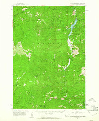
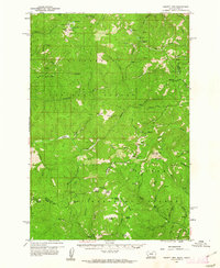
 1959 Cleveland Mountain1961 Print · USGSRavalli and Missoula counties meet along the high ridges of the Sapphire Mountains during the late fifties. Genealogists and historians can locate the Ambrose settlement, trace early timber and mining routes like Woodchuck, or find the Lone Rock Sch near the river.2 unique versions available
 - 1960 Map of Butte
 1960 Butte1960 Print · USGSWestern Montana at the dawn of the sixties is defined by its industrial mining hubs and the railroads that connect them. Genealogists and historians can trace the routes of the Milwaukee Road through Butte or locate smaller settlements like Southern Cross and Bearmouth.
 - 1960 Map of Elk City
 1960 Elk City1960 Print · USGSThe Central Idaho wilderness and Bitterroot Range are captured here during the peak of mid-century industrial mining. Researchers can trace remote backcountry settlements like Burgdorf and Warren, alongside major mineral sites including the Blackbird Mine and Ima Mine.2 unique versions available
 - 1960 Map of Hamilton
 1960 Hamilton1960 Print · USGSThe Bitterroot Valley and surrounding high country are captured here during the late fifties, showing the region's transition into a modern forest and rail corridor. Researchers can trace the path of the Northern Pacific through Missoula or locate landmarks like Fort Missoula and Lake Como.
 - 1960 Map of Painted Rocks Lake, 1961 Print
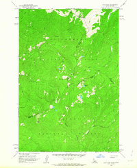
 1960 Painted Rocks Lake1961 Print · USGSThe Bitterroot mountains of western Montana are documented here in the early sixties, showing the remote canyon lands at the state border. Trace historic mountain routes like the Nez Perce Trail and locate the Copper Queen Mine or the settlement at Alta.3 unique versions available
 - 1960 Map of Shoup, 1962 Print
 1960 Shoup1962 Print · USGSThe Salmon River canyon and the Bitterroot Mountains come into focus in the early 1960s, showing a landscape defined by deep-vein mining and forest lookouts. Researchers can trace historic claims like the Kentucky Mine and Gold Hill Mine or locate the site of Reed Ranch.2 unique versions available
 - 1960 Map of Piquett Mountain, 1962 Print
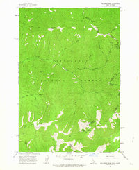
 1960 Piquett Mountain1962 Print · USGSThe high Bitterroot divide during the early sixties shows a landscape of mountain lookouts and remote mining camps. Genealogists and historians can locate isolated sites like Henderson Cabin, Emmett, and the Open Pit Mine near Hughes.3 unique versions available
 - 1962 Map of Butte
 1962 Butte1962 Print · USGSWestern Montana in the early sixties remains a landscape of industrial muscle and high-mountain passes. Trace the rail lines of the Northern Pacific through Deer Lodge and the mining history around Anaconda and Philipsburg.
 - 1962 Map of Dillon
 1962 Dillon1962 Print · USGSSouthwest Montana in the early sixties is defined by its high mountain ranges and the winding rivers that carved its settlement patterns. Trace the rail routes of the Union Pacific through Dillon or locate mining activity near Butte and Argenta.
 - 1962 Map of Blue Joint, 1963 Print
 1962 Blue Joint1963 Print · USGSThe Idaho-Montana borderlands are captured here in the early sixties, where three counties and two national forests meet. Outdoor historians and researchers can trace trails to Surprise Creek Camp, the high waters of Line Lake, and the summit of Squaw Peak.2 unique versions available
 - 1962 Map of Nez Perce Peak, 1964 Print
 1962 Nez Perce Peak1964 Print · USGSThe high Bitterroot Divide comes into sharp focus in the early sixties, showing the vital corridors used to cross the Idaho-Montana border. Trace the historic Old Nez Perce Trail and find landmarks like Nez Perce Peak and Hells Half Acre Saddle.3 unique versions available
Showing maps 1-25 of 174
Top cities of Ravalli County
- Hamilton historical maps
- Stevensville historical maps
- Darby historical maps
- Pinesdale historical maps
- Victor historical maps
Frequently asked questions
- What are the different types of historical maps available for Ravalli County?
- What is the oldest map of Ravalli County?
- Where can I purchase historical maps of Ravalli County for my home or office?
- Where can I download high-res historical maps of Ravalli County?
- Are there historical topographic maps available for Ravalli County?
- Is there historical aerial imagery available for Ravalli County?
- Where are historical maps of Ravalli County sourced from?